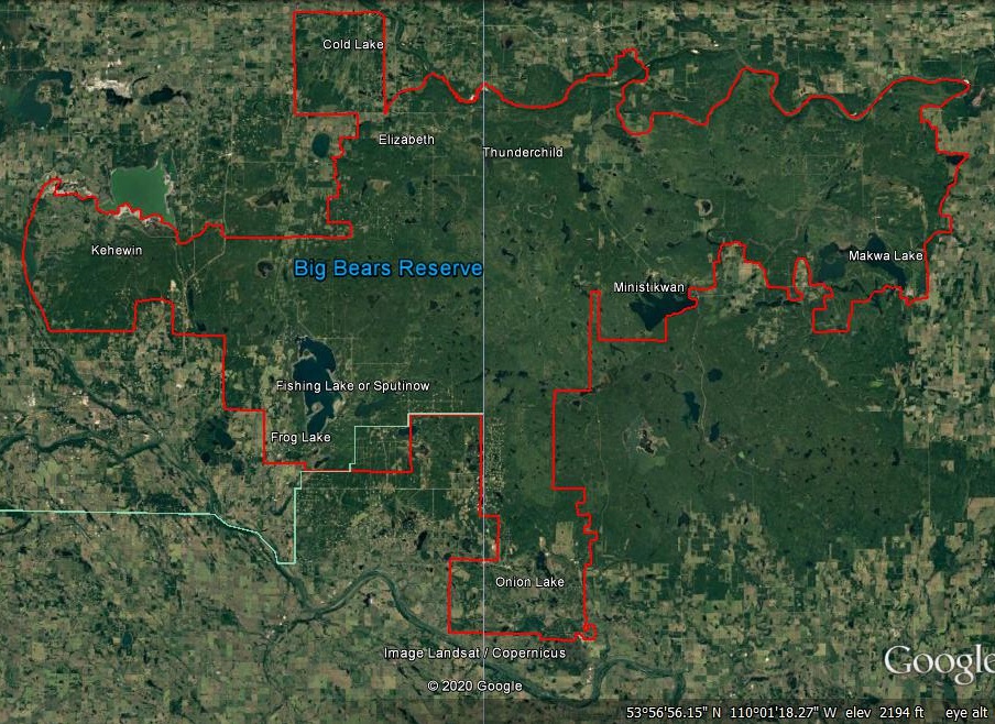
A map of chief Big Bears First Nation Reserve is below. In 1876, chief Big Bear fled Montana with Chief Rocky Boy and chief Sitting Bull and settled around the Cypress Hills of Alberta and Saskatchewan. Canada was quick to offer a treaty which chief Big Bear was late to attend. However, he did reach treaty negotiations before they concluded at Fort Carlton, Saskatchewan. He told Canadian negotiators he would sign treaty yet needed to discuss the situation with other Ojibwa leaders. They were concerned about possible executions. Chief Big Bear made that clear to whites yet they ignored him. In 1877, chief Big Bear signed treaty and agreed to locate his Ojibwa Subjects much further north. Canada refused to set aside Reserves in southeast Alberta and southwest Saskatchewan because of the abundant agriculture land. Chief Big Bear and chief Rocky Boy commenced to leading 1,000's of their Montana Ojibwa Subjects 100's of miles or 100's of kilometers north to Fort Pitt, Saskatchewan. After reaching that location, they commenced to settle at many locations. Chief Big Bears Reserve was quite large. It extended from near Saddle Lake at Alberta, to Sturgeon Lake or Big River at Saskatchewan. North Saskatchewan River was the Reserves south boundary. Canada refused to honor treaty and it led to 1885's Northwest Rebellion which illegally eradicated chief Big Bears Reserve. What remains of Big Bears Reserve are Elizabeth Metis Settlement, Fishing Lake Metis Settlement, Frog Lake Reserve, Ministikwan Reserve, Onion Lake Reserve and Thunderchild Reserve. Canada must add Cold Lake Reserve and Makwa Sahgaiehcan Reserve to Big Bears Reserve! Cree People are really the Athabascan Beaver Tribe (aka Carrier Tribe). There are no Cree First Nations at Saskatchewan, Manitoba, Ontario and Quebec! Below are excerpts from very old books that will help educate you! Look for the 18th century maps. Instead of south to north they are from southeast to northwest. Churchill River is the north boundary. A few Assiniboine and Cree lived west of Lake Winnipeg but were driven to the northwest by 1800 by Ojibwa Soldiers. Churchill River was a boundary used in the 18th century. From Churchill, Manitoba to South Indian Lake, Manitoba to Sandy Bay, Saskatchewan to Buffalo Narrows, Saskatchewan where the source of Churchill River is, this river flows for 1,000 miles. It's source is Churchill Lake, Saskatchewan. All land north of Churchill River is Chipewyan land. Chipewyan is the correct pronunciation of O Chib-bwan or Chib-bwan which means "The Originals and Originals in Ojibwa Language." Remember that white leaders are suppose to prove to Native Americans that whites are the brothers and sisters of Native Americans! That's obviously a concept white leaders can't comprehend.
They are known for not taking treaty. Not just Jackfish Lake Saulteaux Ojibwa's but also Pelican Lake Saulteaux Ojibwa's, Sunchild (probably Thunderchild) Saulteaux Ojibwa's and Witchekan Lake Saulteaux Ojibwa's. To put it bluntly, they continued to honor 1877's treaty. After signing treaty they continued to honor treaty in other words. White leaders always broke treaties! They are those Saulteaux Ojibwa's led by chief Big Bear who dispersed after 1885's Northwest Rebellion and later arrivals from Montana. Fort Battleford or Battleford as it's known today, was a boundary in the 1880's. North Saskatchewan River is the actual boundary. Historically, Saulteaux Ojibwa's of the Battlefords District are known as the Jackfish Lake Saulteaux Ojibwa's, Pelican Lake Saulteaux Ojibwa's (aka Chitek Lake Saulteaux Ojibwa's), Sunchild Saulteaux Ojibwa's and Witchekan Lake Saulteaux Ojibwa's. Sunchild Saulteaux Ojibwa's live at Alberta adjacent to O'Chiese Saulteaux Ojibwa's. They yet live in Saskatchewan but don't know who they are. They were set aside land adjacent to Witchekan Lake in 1915 which means they are more closely related to the Witchekan Lake Saulteaux Ojibwa's. Jackfish Lake Saulteaux Ojibwa's were very much at home from Jackfish Lake (Cochin, Saskatchewan is located on the east side of Jackfish Lake), up to Birch Lake, Helena Lake then up to Meadow Lake. on their west are Sunchild Saulteaux Ojibwa's. On their east are Pelican lake Saulteaux Ojibwa's and Witchekan Lake Saulteaux Ojibwa's. Their continuance on fishing and hunting and trapping was their way of life. Honoring treaty continued until around 1909. During 1909, Canada forced Moosomin and Thunderchild to surrender their Reserve. Canada agreed to accept many Montana Ojibwa's which probably means Moosomin and Thunderchild (Sunchild may be derived from Thunderchild) Reserve leaders thought they had agreed to accept Montana Ojibwa's. Instead Canada forced them to leave Moosomin and Thunderchild Reserve for the Jackfish Lake region. American leaders did not want a large Ojibwa Population at Montana. So many Ojibwa's settled at Montana because of prophesy that American leaders forced several forced relocations of Montana Ojibwa's from 1896 to past 1909. So from Onion Lake First Nation to Flying Dust First Nation to Big River First Nation then southwest to Jackfish Lake then west to Onion Lake First Nation was a large area of land we'll identify as Reserve land not ceded belonging to Saulteaux Ojibwa's. Much of that land continues to be woodlands with many lakes. In 1909, a Reserve was set aside for Jackfish Lake Saulteaux Ojibwa's adjacent to Jackfish Lake. Their leaders agreed to accept their fate! After agreeing to a very small Reserve, Jackfish Lake Saulteaux Ojibwa leaders became uncooperative after being informed Saulteaux Ojibwa's from Moosomin Reserve or Montana were going to be set aside a Reserve next to theirs. Canada then informed Jackfish Lake Saulteaux Ojibwa leaders they could accept land that they selected at Witchekan Lake. Afterwards, some Jackfish Lake Saulteaux Ojibwa's made for land they selected at the Witchekan Lake region.
Their domain was further north and primarily located where Chitek Lake is. Since they continued to honor the treaty chief Big Bear signed in 1877 after fleeing his native Montana, they had much land to use to use to subsist on. Their curent Reserve is 78 miles east of chief Big Bears Onion Lake First Nation which is a part of chief Big Bears Reserve. Many can trace their origins to Montana. After 1900, white invaders forced their way to the south portion of their land. That's why they agreed to accept very small Reserves which they knew meant they have no future. From Meadow Lake to south of Chitek Lake then northeast to Big River they went about their daily lives while their leaders became ever more concerned about Canada. Green Lake, Saskatchewan was probably their north boundary.
Their district commences northwest of Jackfish Lake and extends northwest to Thunderchild (they are probably Thunderchild Saulteaux Ojibwa's and Moosomin Saulteaux Ojibwa's) near Turtle Lake then to Flying Dust or Meadow Lake then west to Makwa Lake then to Onion Lake First Nation. On their east is the Pelican Lake Saulteaux Ojibwa District. Most of the Sunchild Saulteaux Ojibwa District is covered by a forest and lakes. Sunchild was possibly another of chief Rocky Boy's names or is, in fact, derived from Thunderchild. Before whites settled their land they were very content living by fishing, hunting and trapping. Their leaders became very concerned after white settlers invaded their lands. That forced them to accept treaty. Some fled to Alberta where they now live adjacent to O'Chise Ojibwa's. In 1915, some Sunchild (probably Thunderchild) Saulteaux Ojibwa's selected land north and south of Sylvander Lake and became a part of the Jackfish Lake Saulteaux Ojibwa Witchekan Lake Reserve.
Their district commences south of Sylvander Lake up to near Chitek Lake then east to Big River. On the west their district was adjacent to that of Jackfish Lake Saulteaux Ojibwa District and Sunchild (probably Thunderchild) District. On the east their district was adjacent to Big River First Nation and Ahtahkakoop or Starblanket First Nation. Since there is a connection between Pelican Lake and Big River, we have to include Ahtahkakoop, Big River, Mistawasis, Muskeg Lake and Sturgeon Lake as being Saulteaux Ojibwa's. Most of their land is covered by a forest and lakes. Witchekan Lake appears to have been the principle location of chief Big Bears Saulteaux Ojibwa's who continued to honor 1877's treaty. Canada refers to them as "Stragglers." American leaders term them "Landless." Saulteaux Ojibwa's from Jackfish Lake and Sunchild (probably Thunderchild) settled at Witchekan Lake as did Montana Ojibwa's.

Look for the mountain peak shape on the map. That's where Churchill is located. Churchill River is almost adjacent to Churchill Town. Part London of Hudson Bay is written above the mountain shaped peak. You can tell it's been violated! It should read "Part of Hudson Bay." Andrew Graham drew the map in 1774. In 1991, another source "Ruggles," either copied the 1774 map of Andrew Graham or changed it. Lake Winnipeg and Lake Manitoba (Mantouabau) look awkward! That's because the map is from southeast to northwest. Nekawawuck Indian Country represents Northern Ojibwa Territory. It's definition is not known. However, the "ne" represents point in Ojibwa Language so it refers to a place and people. Discovering what "ka-wa-wuck" means won't be easy! Word for "Freezing" in Ojibwa Language is either "Mash-ka-wad-ji-win or Ga-wad-ji-win." The 'd' is not pronounced. It's used to let learners know that the following 'j' is pronounced like judge, just, ect. Not like 'zhi.' Ne Ka-wa-wuck probably means "Point Freeze People." Pronunciation is "Nay Ga-wa-wug." An excellent description of the Churchill, Manitoba region! Of course, you've noticed the point where Churchill is! Keskachewan (Italians and the Beaver Tribe or Cree) Territory extends to almost Nunavut. Dogrib Territory (Ateemouspecky) Territory is located at southwest Nunavut.

This is a satellite image of the same region from google earth. It's from a southeast to northwest direction. It fits in well with the 1774 Andrew Graham Map. Lake Winnipeg looks almost similar to how it's depicted on the 1774 Andrew Graham Map.

What did they mean by "Keskachewans Resort Prior To European Settlements?" Were they indicating the Keskachewans resorted to migrate west. If they did resort to a west migration, Graham was writing about the establishment of Cumberland House at Saskatchewan in 1774 by Samuel Hearne. That would confirm the Keskachewans were Europeans with some of the Beaver Tribe (the Assiniboine and Cree) who sneaked their way to what is now the Cumberland House Region of Saskatchewan in 1774. Italians had already reached that area decades earlier! That's why Graham was familiar with that region! If Graham was referring to Italians reaching Manitoba and Saskatchewan in the 1730's and early 1750's that is! Fort de la Corne was built in 1753. It was located east of what is now Prince Albert, Saskatchewan almost adjacent to the east border of James Smith Reserve. Fort La Jonquiere was built in 1751 and was located near what is now Nipawin, Saskatchewan. Italians had established forts at south Manitoba in the 1730's. Using alcohol and drugs they lured in idiotic Ojibwa's (the Beaver Tribe or Assiniboine and Cree) who pitched their camps near the three Italian Forts built at south Manitoba. After Ojibwa Soldiers drove the Italians out during 1750-1763's War, those idiotic Ojibwa's relocated to European Forts adjacent to Hudson Bay. If Keskachewans do represent Europeans it means Northern Ojibwa Territory extends as far north as the Arctic Ocean! Graham wrote "NORTHERN KESKACHEWAN - BEAVER INDIANS." Cursive writing on the maps is very difficult to decipher. Graham was certainly referring to Europeans and idiotic Ojibwa's (the Assiniboine and Cree) as being the KESKACHEWANS AND BEAVER INDIANS. SOUTHERN KESKACHEWANS REPRESENT EUROPEANS OR ITALIAN'S. Evidently Italians continued to live at south Manitoba in the late 18th century. Though Graham wrote Assiniboine as Asenepoets we know who they are. Asenepoets is pronounced 'Ah-sin-ni-poats.' Read the following carefully. At Island Lake, Manitoba, Ojibwa leaders of Garden Hill, St. Theresa Point, Wasagamack and Red Sucker Lake are so stupid they don't know what "Oji" means. It's a combined word meaning "The originals." The "O" means 'the' in Ojibwa Language. Similar in sound to the Ojibwa word for 'that' which is "aw." It's pronounced "ow." It ryhmes with 'cow.' Oji is from "O Tchi Bwa." Word for before as in original in Ojibwa Language is "Tchi Bwa." It's pronounced "Tchib Bwa." Some Ojibwa Language Dialects pronounce it "Ji Bwa or Jib Bwa." They're scared and looking for excuses!


