Search Site Anishinabe | Algonquian Tribes | Ojibway Language

Shoshone Ojibwa's | Ojibwa Tribes


Coeur d'Alene Reservation


Located in northern Idaho, Coeur d'Alene Reservation has a bitter past and a corrupted history written for them by whites. Why? An obvious Ojibwa presence in that region of North America! Below is a map of an unceded area of land numbered 532 (parts of this land area is located at far western Montana), 533, 536 and 552 (It's Coeur d'Alene Reservation) in Washington, Idaho and Montana where Coeur d'Alene Reservation is. It is a very large Ojibwa Reservation that was violated by American leaders. It was created by one of the Stevens Treaties. In 1859, this vast Ojibwa Reservation was officially agreed to. American leaders were only too willing to set aside this vast OJibwa Reservation. It's nearly all mountainous land as you can clearly see on the map. You'll notice original Coeur d'Alene Reservation created on June 14, 1867, is adjacent to land area number 532 or the land depicted on the map. I drew the map and included Coeur d'Alene Reservation! In mid 19th century, whites initiated an invasion into California, Oregon and Washington. Most natives at time of that invasion, were subjugated by Ojibwa Nation's military and police. Chinese and Filipino People were already living in that region long before whites discovered America. They were also involved. Starting in late 1840's, Ojibwa Soldiers commenced to fight invading whites who were invading their territory by Pacific Ocean and to a leeser degree, by land. At that time, whites had superior weapons (revolvers) and easily dominated Ojibwa Soldiers. More wars erupted in 1850's which led Ojibwa leaders to reach an agreement with whites which ended this fighting by 1859. A series of mid 1850's treaties known as Stevens Treaties, were signed that led to creations of Reservations. By 1859, treaties for ceding land had stopped for a time at Washington. On November 8, 1873, American leaders took possession of a large area of land in north Idaho and east Washington, without permission from Ojibwa leaders. Coeur d'Alene Reservation is within that land area. American leaders dealt with enraged and strict Ojibwa leaders at Idaho, Montana, Oregon and Washington. Coeur d'Alene Reservation is different because from the land area depicted on map below, it was set aside from same land area or adjacent to same land area. It's within land area (land numbers are 552 and 553 with land number 553 being native land) American leaders took without permission. On June 14, 1867, Coeur d'Alene Reservation was created. They refused to accept Reservation. What they actually did was continue to honor the agreement that set aside vast Spokane Ojibwa Reservation. After many years of rejection, an agreement to accept Reservation was illegally agreed to.


Coeur d'Alene War

A continuation of the Yakima War, the Coeur d'Alene War was fought to force the United States to accept Ojibwa leaders demands of a large Ojibwa Reservation located at Idaho, Montana and Washington as depicted on the map below. Coeur d'Alene War was actually an extension of Mullan Road War. At issue was Ojibwa leaders demands for a large Ojibwa Reservation. Isaac Stevens at first rejected the Ojibwa demand then war erupted and lasted from 1855 to 1859. By 1859, American leaders agreed to set aside the large Ojibwa Reservation as depicted on the map below. As a result of prophesy, a very large Ojibwa Population lived at Washington, Idaho and Montana that numbered near 100,000. American leaders originally demanded small Reservations yet Ojibwa leaders rejected! After a serious of battles fought near Spokane, Washington as as depicted on the map below, American leaders agreed to set aside the vast Reservation we'll name Spokane Ojibwa Reservation. A migration of 10,000's of Ojibwa's living south of the Reservation to Spokane Ojibwa Reservation followed. Though Mullan Road War continued, a long period of peace prevailed at Idaho and Washington. That changed in 1877. Ojibwa leaders continued to refuse to cede Reservation. In fact, chief Rocky Boy possibly refused to cede this Reservation. From Spokane Ojibwa Reservation, several much smaller Reservations were illegally created. They are Coeur d'Alene, Columbia, Colville, Kalispel and Spokane Reservations. Most Ojibwa's and other natives who lived at Spokane Ojibwa Reservation were forced to leave Reservation. Most settled south of the Reservation or between Colville Reservation and Yakima Reservation, on their land allotments they either sold to whites or had them forcefully taken from them.


In 1873, an agreement was reached in which they agreed to cede land area number 533 in Idaho and Washington. However, American leaders rejected the agreement for some unknown reason. Probably because Coeur d'Alene Reservation created on June 14, 1867, was adjacent to land area number 532. That needs further research by historians because of obvious illegal actions. American leaders assumed when they accepted the Reservation in 1873, they agreed to cede their territory. Another illegal treaty about land in Idaho, Montana and Washington adjacent to land area number 533, is of great concern. In December of 1871 (They list December 0, 1871 as when this illegal action happened), another illegal American action took possession of a large area of land (it's number is 532) in Washington, Idaho and Montana. Ojibwa leaders refused to ratify treaties. Land area numbers 533 and 552 has Coeur d'Alene Reservation. Land area number 532 has Columbia Reservation, Colville Reservation, Spokane Reservation and Kalispel Reservation. Coeur d'Alene Reservation is within this vast Ojibwa Reservation! What needs to be confirmed is if original Coeur d'Alene Reservation created on June 14, 1867, was within land area number 532. We know Coeur d'Alene Reservation was! The map below shows boundaries of land area number 532. We can acclaim Coeur d'Alene Reservation was a Reservation created from land area number 532 and not 533. However, both land areas can be used! Historians claim it was a part of land area number 553!


Chief Rocky Boy

In 1902, chief Rocky Boy became highest ranking Ojibwa leader. He was elected to that position in early 1902 near Anaconda and Butte or at Lemhi Reservation. His power extended to Canada and south to Mexico! He took notice of his Ojibwa Subjects approval to accept land allotments. That enraged Ojibwa leaders forced out of their high ranking positions. They nearly had a Civil War according to newspaper accounts. Chief Rocky Boy contacted an Anaconda lawyer to help him write a letter to President Roosevelt. They sent off his letter to President Roosevelt in early 1902. Chief Rocky Boy told President Roosevelt that chief Rocky Boy was leader of landless (Ojibwa's without land allotments off and on Reservations) Ojibwa's at various locations in the United States in need of land. That was his way of letting President Roosevelt know that he would accept land allotments within Reservations. Chief Rocky Boy also requested for new Ojibwa Reservations. Supposedly President Roosevelt rejected chief Rocky Boy's proposals. However, a couple months later, chief Rocky Boy was told land allotments within Reservations was approved! Chief Rocky Boy agreed to accept land allotments as long as if they were in compact form and could not be sold. He also agreed to cede any surplus land left after land allotments yet not at all Reservations. That information must be strictly observed becaused American leaders violated Coeur d'Alene Reservation.


Before Coeur d'Alene Reservation land allotments and Reservation Surplus Land was agreed to, Coeur d'Alene Reservation's land area was 330,084 acres. It's not known when chief Rocky Boy agreed to allot land to Coeur d'Alene Reservation's Ojibwa's. However, on April 30, 1909, Coeur d'Alene Reservation's land allotments became official. Chief Rocky Boy had a difficult year in 1909. This evidence indicates chief Rocky Boy did not agree to certain conditions that President Roosevelt agreed to. A total of 104,077 acres was allotted to 638 Ojibwa's at Coeur d'Alene Reservation in 1909. Another 1,907 acres was set aside for Reservation purposes. None of that land could be sold and it was in compact form. It is a reduced Coeur d'Alene Reservation with a land area of 106,684 acres. We need to know where it is. We know it's nearly all mountainous land! After land allotments were granted, Coeur d'Alene Reservation's land allotments became todays Coeur d'Alene Reservation. CR's Surplus Land was ceded. American leaders betrayed chief Rocky Boy again who agreed to allow land allotments as long as if they were in compact form and could not be sold. American leaders allowed each allottee to sell her/his land allotment. It was an illegal action! After American leaders broke agreement, they became subject to "Criminal Activity." They went so far as to use deception to conceal their crimes or broken agreements! 
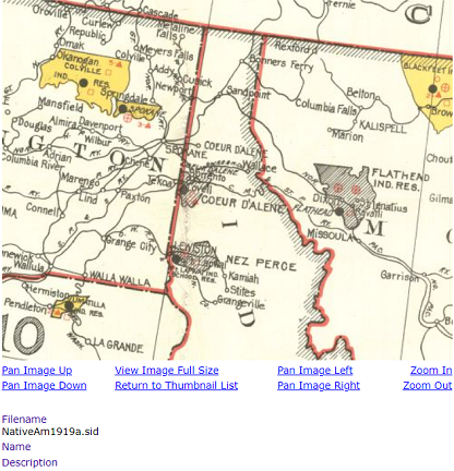
Chief Rocky Boy agreed to allow land allotments within Reservations, as long as if they were in compact form and could not be sold. Don't be deceived if you read information that Coeur d'Alene Reservation has a land area of over 300,000 acres or over 500,000 acres because the Reservation doesn't!


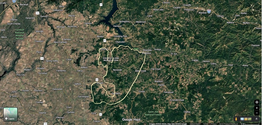
Coeur d'Alene Reservation was considered a "Former Reservation" for much of the 20th century. However, they promoted that because of the new smaller Coeur d'Alene Reservation created after land allotments were handed out and surplus land was ceeded. Those land allotments became the new smaller Coeur d'Alene Reservation! We can't determine correct demographics of Coeur d'Alene Reservation because the preserved land has been extremely violated. That's why demographics are not included! There are two communities within Coeur d'Alene Reservation where Ojibwa's make up a large proportion of it's population. De Smet is Coeur d'Alene Reservation's only predominantly Native American community. Plummer is near half Native American. West portion of Coeur d'Alene Reservation is the surplus land that was ceded. From Plummer to De Smet to St. Maries is probably Coeur d'Alene Reservations correct boundaries. It's nearly all mountainous.


Contact


© 2009-2025 Anishinabe-History.Com