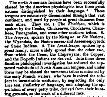
Athabascan Indians are also known as Dene. Dene is very similar to Algonquin words for man. Examples are Lenni (Delaware), Nini (Chippewa), and Hetane (Cheyenne). Of course, the closest one being the Cheyenne word for man which is Hetane. Exclude "he" and just pronounce "tane," and you learn that Dene and Tane sound almost identical. According to 1832's Edinburgh Encyclopedia (a jpg phot of it is below), Athabascan People are Lenni Lenape or Ojibwa. In British Columbia and the California, Oregon, and Washington regions Athabascan or Dene history, is different from the history of the northern most Athabascan's or Dene, which is written below. However, in many respects it is very similar. They had to deal with a foreign Asian people who were probably Chinese and Filipino, who invaded western North America (between southeastern Alaska and northwestern Mexico or the Mexican State of Sonora) 1,000's years ago. They were possibly provoked into invading by the Chippewa's invading eastern Asia or better yet were brought to the America's by Ojibwa's. Over time, they evetually sailed to the America's on their own! There was a difference, however, in the Aleut's and Eskimo invasion compared to the Chinese and Filipino invasion. Aleut's and Eskimo People were brought to the region between extreme northern Alaska and Hudson Bay by the whites after 1492, to fight wars for white invaders. Below is a list of Athabascan Peoples and where they live.
Originally, Chipewyan (Chipewyan is pronounced Chip-ah-won) People lived at far northern Manitoba and parts of what are now eastern portion of Northwest Territories and Nunavut. Andrew Graham drew a map of native peoples living adjacent to Hudson Bays west shores and to the west, south and north in 1774. Reason for Graham drawing the map was to depict northern Ojibway Territory. On the 1774 map, Andrew Graham wrote the name of The Northern Ojibway People as The "Nekawawuck Indian Country." It's definition is "Point Freeze People." Point as in a point of land extending out into a lake. Ojibwa's named the location where Fort Churchill was "Ne Ga-ah-wug."
Only Chipewyan People have kept the Ojibwa "n" plural in use. Translation of 'Chipewyan' is "Originals." Adding the Ojibwa word for 'the' to Chipewyan, it becomes "O Chip-ah-won." Translation, of course, is "The Originals." Ojibwa's named themselves "The Originals" to let Europeans know that Ojibwa People were here first. In response, Europeans use "Aboriginals" which is a threat. The English prefix "ab" defines absent, gone, ect. Samuel Hearne indicated on his map that Chipewyan People lived at what is now Nunavut. He named them "Northern Indians." We know from the 1774 map of Andrew Graham that Chipewyan People are Northern Ojibwa's. To their west were Copper People (they may have been Russians) and south of Copper People the Dogrib People who lived adjacent to and north of Great Slave Lake. Samuel Hearne was familiar with the region and knew the Beaver Tribe were already living at northeast Alberta. He placed their territory southwest of Arathapescow Lake (Great Slave Lake) and southwest of Arathapescow People (Athapasca Ojibwa's). Hearne knew Ojibwa Traitors working for Hudson Bay Company were already causing civil unrest as far west as Alberta. Matonabbe was sent there yet often met with hostile Ojibwa leaders. And Matonabbe wasn't the only Ojibwa Traitor who worked for Hudson Bay Company sent to what is now north Alberta. Doing what they did was extremely risky and led to the July 17, 1771 massacre. A vicious war was going on between Chipewyan People and the invading whites and Inuit and they actually had the nerve to venture far west of Hudson Bay to lure idiotic Ojibwa's to HBC Forts and trade posts at Hudson Bay. And they did convert many idiotic Ojibwa's to becoming Ojibwa Traitors by use of alcohol and drugs. Their lives were dangerous ones!
Since we have evidence (we have to obey prophesy and find evidence along the trail) of Northern Ojibwa's being Chipewyan, it means we must extend the territory of Chipewyan People to Churchill River at Manitoba. Dogrib People lived at north Saskatchewan and northwest Manitoba during those times (mid 18th century) and the land from Arathapescow Lakes (Great Slave Lakes) east. The Yellowknifes were living to their north at what is now the east portion of Northwest Territories up to the Arctic Ocean. Coppermine River was possibly their west boundary. After Ojibwa leaders agreed to a truce in 1774-1794's War in 1783, they permitted England to establish trade posts at what are now north Alberta, north British Columbia and Northwest Territories. Americans made themselves at home at the trade posts then converted them to forts that were controlled by Hudson Bay Company. After the trade posts were established, Russians were invited to live at them. McKenzie River became dominated by Europeans yet Ojibwa Soldiers continued to be a force to deal with. At Great Falls, Montana, Ojibwa leaders sent large numbers of Ojibwa Soldiers and their families to central and north Alberta to reinforce Ojibwa's native to that location. Dealing with Europeans was terrible yet to have to deal with the Beaver Tribe (the Assiniboine and Cree who were Ojibwa Traitors) made it far worse. To attempt to prevent innocent Ojibwa's from becoming traitors, Ojibwa Soldiers were ordered to enslave those they knew were troublemakers. Today their known as the Slavey Tribe. They're western Chipewyan's. By 1790, Chipewyan's had migrated to east Alberta to Arathapescow Lake (Great Slave Lake) which forced the Arathapescow People (probably Slavey People) to migrate further north and west of Arthapescow Lake (Great Slave Lake) and that proved to be a concern to Ojibwa leaders who did not want Europeans causing civil unrest among Ojibwa People!
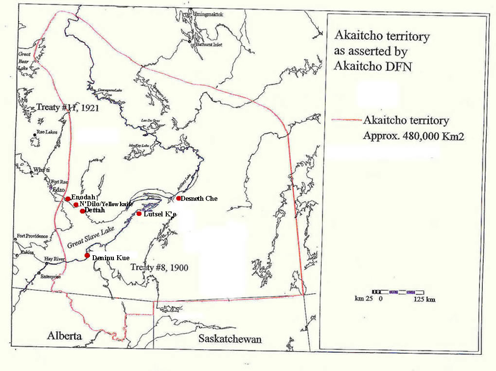
However, according to 1832's Edinburgh Encyclopedia, they lived southeast near Lake Superior and are Chippewa or Ojibwa. They migrated to a location just south of Hudson Bay then to Northwest Territories including Nunavut, then into northeast Alaska. Most of their district is now termed Barren Grounds. Chipewyan's Akaitcho Territory? covers 298,258 sq. mi. or 480,000 sq. km. We can't name their Reserve a territory! It is a Reserve Canada is concealing from the public! By promoting their Reserve as a territory, Canadian leaders are pretending that Akaitcho Territory has yet to be ceded. However, it's a Reserve! They must always refer to their land as a Reserve and demand of Canadian leaders that Akaitcho Reserve must be protected since they are a Protectorate of Canada! Don't give up! We won't recognize any land cessions by Akaitcho Reserve leaders. We will consider them invalid. We won't recognize any land cessions by Akaitcho Reserve leaders. We will consider them invalid. If they cede Reserve land we won't let them live again in the future! Below is a list of Chipewyan Reserves and a map of their largest Reserve which is Akaitcho Reserve. They must allow the Little Red River Reserve and Tall Cree Reserve to become a part of Akaitcho Reserve. And negotiate with Canadian leaders for equal ownership of Wood Buffalo National Park.
Cold Lake - Alberta
Fort Chipewyan - Alberta
Fort McKay - Alberta
Fort McMurray - Alberta
Janvier - Alberta
Barrens Land - Manitoba
Churchill - Manitoba
Sayisi Dene - Manitoba
Northlands - Manitoba
Buffalo River - Saskatchewan
Black Lake - Saskatchewan
Clearwater River - Saskatchewan
English River - Saskatchewan
Fond Du Lac River - Saskatchewan
Lac La Hache - Saskatchewan
Patunanak - Saskatchewan
Stony Rapids - Saskatchewan
Turnor Lake - Saskatchewan
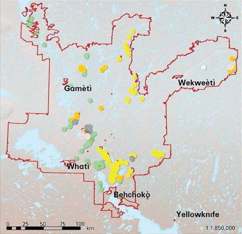
They are also Chipewyan. They are not one of them two tribes who claimed to have migrated from a west location where no winters existed and an animal with human facial features lived. Those two tribes are Aleut's and Eskimo. Dogrib People (Tlicho people) have a territory? of 15,100 sq. mi. or 39,000 sq. km. It's in compact form and not acceptable to our laws! Their nation is actually a part of Akaitcho Chipewyan Reserve. Tlicho Territory is not a territory. It is a Reserve Canada is concealing from the public! By promoting their Reserve as a territory, Canadian leaders are pretending that Dogrib Chipewyan Territory has yet to be ceded. However, it's a Reserve! They must always refer to their land as Tlicho Reserve and demand of Canadian leaders that Tlicho Reserve must be protected since they are a Protectorate of Canada! Below is a map of Tlicho Territory. However, they're a part of Akaitcho Chipewyan Reserve!
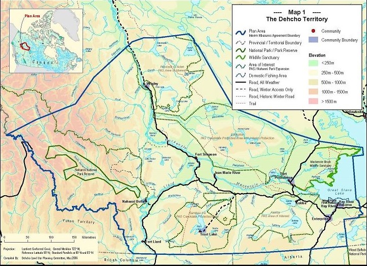
They are also Chipewyan. Samuel Hearne named them Athabasca People! These northern Saulteaux Ojibwa's known as Sahtu (it's a different pronunciation of Saulteau and Saulteaux), have a territory? located at the Alberta/Northwest Territories bounday east to adjacent to Akaitcho Chipewyan Reserve and west to the Yukon border. It extends well north well north of Wrigley, Northwest Territories. We can't name their Reserve a territory! It is a Reserve Canada is concealing from the public! By promoting their Reserve as a territory, Canadian leaders are pretending that Decho, Sahtu or Slavey Chipewyan Territory has yet to be ceded. However, it's a Reserve! They must always refer to their land as a Reserve and demand of Canadian leaders that Decho Reserve must be protected since they are a Protectorate of Canada! Dehcho Reserve covers 83,000 sq. mi. or 215,000 sq. km. Don't give up! We won't recognize any land cessions by Decho Reserve. We will consider them invalid. We won't recognize any land cessions by Akaitcho Reserve leaders and Dehcho Reserve leaders. We will consider them invalid. If they cede Reserve land we won't let them live again in the future! Historically, these Ojibwa's caused Ojibwa People much trouble after England established forts at north Alberta, north British Columbia and the Northwest Territories. To prevent them from siding with whites, Ojibwa Soldiers were ordered to enslave them!
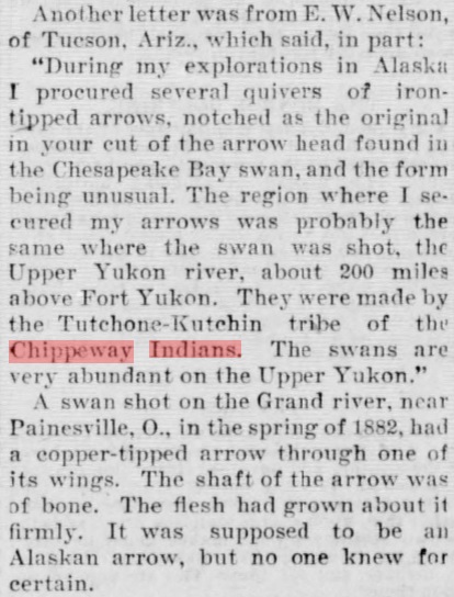
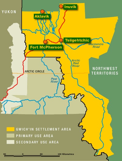
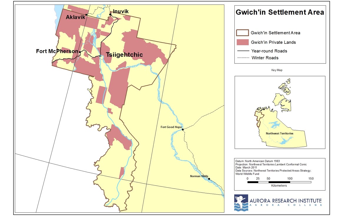
They are also Chipewyan as well as Inuit and Russian. There are two different Gwich'in People! One is made up mostly of Algonquin's, while that other is mostly Inuit. Those who are mostly Inuit are one of them two tribes who claimed they lived at a west location where no winters existed and an animal with human facial features lived. Gwich'in People live at Alaska, Northwest Territories and the Yukon in Canada. In 1992's Gwich'in Comprehensive Land Claim Agreement, Gwich'in People were left with 21,983 sq. mi. or 56,935 sq. km. in Northwest Territories. Part of that land is located at the Yukon. However, it's not in compact form. We don't accept that! There are currently 9,000 Gwich'in. At Alaska, Gwich'in People live at the towns of Arctic Village, Beaver, Birch Creek, Chalkyitsik, Circle, Fort Yukon, and Venetie. You would think weather is cold year round at those villages but they have warm summers. For an example, at Chalkyitsik which is north of Fairbanks (Chalkyitsik is at 66 degrees north latitude while Fairbanks is at 64 degrees north latitude), it is warmer during summer months. Average summer highs at Chalkyitsik for June, July and August are a balmy 71.5, 73.1 and 68.5. Most people think Alaska does not get too hot during summer time but they are obviously wrong. We know Gwich'in People are Ojibwa! However, their territory was compromized in the early 18th century after Russians and their Inuit allies forced their way to McKenzie River. Gwich'in People were forced south and west. How far south they retreated is not known. Possibly well south of Aklavik and Inuvik. Gwich'in People are also known as "Kutchin and Tutchone." Their vast Reserve at Northwest Territories was violated by Canada because of their claims to land where Aklavik and Inuvik are. After agreeing to a reduction in their Reserves size, they were left with several smaller Reserves. We must reject their 1992 land settlement agreement and create a more southerly Gwich'in Compact Form Reserve. Below is a September 19, 1896 news article that will educate you and maps of the original Gwich'in Reserve and the smaller Gwich'in Reserves created after 1992's land agreement.
To better understand who the Beaver Tribe are, we need to research historical data! They must be classified as being a part of the North Central Athabascan Language group Chipewyan. Their name "Beaver" arose as a result of trapping beavers. Besides trapping beavers they trapped other wild game. Hudson Bay Company, North West Trade Company and others employed them. They caused Ojibwa People much "Civil Unrest." Chipewyan People are Ojibwa. They live at Nunavut, Manitoba, Saskatchewan, Northwest Territories and Alberta. Chipewyan People include the Copper, Cree, Dogrib and Yellowknifes. Gwich'in People are also probably Chipewayan as are Slavey People. Chipewyan People were different from the Beaver Tribe. Besides being far more numerous than the Beaver Tribe, they fought a long war against the Inuit and whites. Some Chipewyan People did become traitors. An example is Ma-to Na-bee! This following historical data will help you understand what whites were causing among Ojibwa People of those times. It was to instigate "Civil Unrest." Matonabbe was a notorious "Pimp" who used women for his own advantage. He told Samuel Hearne that women were necessary on expeditions to carry supplies. Instead of using their dogs to sled their supplies, they used women to carry many pounds of supplies. Not only that, they also forced women to do most of the work. Ojibwa Traitors did not observe Ojibwa Totemic System Laws. What they did observe was promotion of illegal activity. Matonabbe had at least 8 prostitutes if not more, that Hearne wrote were the wives of Matonabbe. Matonabbe took Samuel Hearne to McKenzie River in 1771 but before they could reach McKenzie River a force of 200 or more Chipewyan Soldiers (Athabasca Ojibwa's) captured them at Clowey Lake (Garde Lake). Being kind they allowed two of Matonabbe's prostitutes to leave. Being upset with a man who had his wife abducted by a "Pimp" who sold the man's wife to Matonabbe, the man asked for his wife back but Matonabbe stabbed him three times in the back. He would have killed the man who had his wife taken captive by the other "Pimp," if not for Matonabbe being talked out of it. Then Matonabbe got into an argument with the "Pimp" who sold the woman to him but was quick to back down and play Muslim. Matonabbe was near 6 feet tall yet the other "Pimp" was larger! In Ojibwa, the name 'Matonabbe' probably means "Travel Man." It's derived from the Ojibwa word for travel which is Ma-da (it's from Madadisiwin) and the Ojibwa word for male which is "Na-be." Thus, Ma-da Na-be or "Travel Man." Matonabbe was an extensive traveler. We'll list him as a Carrier. More about the Carrier People (they're possibly from the Beaver Tribe) is written below. Matonabbe was a Carrier! Ojibwa Soldiers forced nearly all to retreat to Central British Columbia.
Matonabbe lived much of his life at Fort Churchill. He made his living luring idiotic Ojibwa's to alcohol and drugs. Once addicted to alcohol or opium (be them man or woman or child), they were easy to convert to being idiots. Matonabbe was in serious trouble with Athabasca Ojibwa's who hated him. It was Athabasca Ojibwa's who captured Matonabbe and Samuel Hearne and their crew. Athabasca Ojibwa leaders were very willing to tag along with Matonabbe and Samuel Hearne and their crew. Upon reaching Copper People (they may have been the Yellowknifes) Athabasca Ojibwa Soldiers disamred them and allowed them to journey with them. The incident took place near a lake Hearne named Gogead Lake which is located north or northwest of Great Bear Lake. According to Hearnes calculations (coordinatons or measurements) they were at 68 degrees 46' north latitude (slightly south of the mouth of McKenzie River) or east of McKenzie River. Coppermine River and Kuglugtuk are situated at 67 degrees north latitude. During their initial meeting, the Copper People (probably Yellowknifes) looked over Samuel Hearne and described him very favorably. Worse, they insisted that the English establish a settlement or fort near them. That they should not have done! Athabasca Ojibwa's were there and freely admitted to Samuel Hearne they were going to kill some "Ish-gi-moag People" after reaching the McKenzie River Delta. They meant they were going to slaughter some Russians. Hearne was, after all, sent on his expedition to find the Northwest Passage and Russians. It was the Russians who used small boats to sail the Arctic Ocean from Alaska to Hudson Bay to bring Inuit People to Hudson Bay.
Back at Fort Churchill, they conspired to find an overland route to McKenzie River. It was too risky to use large ships to sail from Hudson Bay to McKenzie River. Samuel Hearne and also Matonabbe feared Athabasca Ojibwa's. It was Matonabbe who led Hearnes crew from Fort Churchill then to Seal River then to the region just west of Kasba Lake then up to Clowey Lake (Garde Lake). He was even more reluctant to travel west to the source (Great Slave Lake) of McKenzie River than Hearne. Their selected route was far more rugged and mostly at the Barren Lands. After reaching Clowey Lake (Garde Lake) before them was the tremendous Barren lands. Hearne tried twice before to reach McKenzie River by journeying northwest from Fort Churchill yet encountered much trouble on each occasion. Leaving during the winter was to prevent any encounters with Chipewyan People. Most Chipewyan's left the Barren Lands during the winter months. However, Hearne was aware that many Chipewyan People kept their residence at the Barren Lands north of Ennadai Lake and Nueltin Lake. Avoiding both those locations was crucial. When Athabasca Ojibwa Soldiers captured Matonabbe he knew he was no longer in charge. Hearne describe Copper People (the Yellowknifes) in a very peculiar way. He wrote that some of them were impressed by his hair and eagerly requested of Hearne to give them some of his hair after he combed his hair. It's biblical which means they were converts to Christianity or were possibly white. Athabasca Ojibwa Soldiers were most definitely observing the interactions between Hearne and the Copper People (the Yellowknifes) and commenced to mistreat the Copper People (the Yellowknifes). According to Hearne both the Chipewyan and Copper People (the Yellowknifes) spoke the same language. Samuel Hearne was not honest describing some events or his journals were later violated.
In early July 1771 they were near small mountains named Stony Mountains at 68 degrees 46' north latitude. My guess is they were at what is now Tuktut Nogait National Park which is at 68 degrees 46' north latitude. They were less than 300 miles east of McKenzie River which means climate conditions must have been warm yet Hearne wrote of constant snow! Both Aklavik and Inuvik are situated at 68 degrees north latitude and summers are mild at that region. Although the latitude is at 68 degrees north, the region averages close to 100 days yearly with maximums in the 60's and warmer. July's at Inuvik have a maximum of 66 degrees. On July 6, 1771, Hearne wrote of a strong storm from the northwest causing them to find shelter under rocks at the Stony Mountains. Elevation where they were at is well under 2,000 yet Hearne described a vicious snow storm with very large flakes. He also described a frozen lake. Remember they're at 68 degrees 46' north latitude which means they were not at Coppermine River which is located at 67 degrees north latitude. What Hearne or a person or persons violating Hearnes Journals described, was a vicious Hail Storm. After it finished, they came out from under the rocks and continued their journey to McKenzie River. What Hearne wrote from the time they left the women at 67 degrees north latitude (the Coppermine River region) to McKenzie River is very incorrect. It's incorrect because of the vicious massacre Athabasca Ojibwa Soldiers committed at one of the camps at McKenzie River. It took ten days for them to reach McKenzie River from the Stony Mountains which adds up to about walking 25 miles a day. Athabasca Ojibwa leaders sent their scouts to the north to survey for possible settlements. After returning they informed their leaders that two camps were located on each side of McKenzie River. Each camp was adjacent to each other excepting the McKenzie River which flowed between them. McKenzie River is not a small river. It's width at that region is anywhere from just under a mile to over two miles.
Hearne wrote that the massacre took place at Bloody Falls at Coppermine River yet he let the future know otherwise. For some reason Athabasca Ojibwa Soldiers targeted the smaller camp on the west side of McKenzie River. As many as five tents were located there when Ojibwa Soldiers commenced killing their Russian enemies. Historians claim that 20 were killed in the massacre. Why Ojibwa Soldiers didn't attack the larger camp on the east side of McKenzie River is not known. Hearne was visibly troubled by the murder of a young lady I suspect he was smitten with or knew. Hearne though her to be aged 18. Two Ojibwa Soldiers stabbed her with their lances and she kept the life in her which caused Hearne to become very upset. How he could communicate with Ojibwa's is not known. Hearne was from England and only recently arrived to Fort Churchill around 1768 or 1769. Either he had an interpreter (probably Matonabbe) or quickly learned how to speak Ojibwa. He was told by the two Ojibwa Soldiers that he wanted for himself an "Ish-gi-moag" wife." Ojibwa's were first calling whites "Ish-gi-moag" before applying the same name to the Inuit. Read Seven Fires Prophesy! In Ojibwa Language the definition of "Ish-gi-moag" is "Mystery People and Secret People." Hearne pleaded with the two Ojibwa Soldiers to quickly murder her which they obilged. Soon after, an old woman was captured while she fished for salmon. Only Arctic Char Salmon are known to be native to that region. Bloody Falls is a set of rapids easily tested successfully by Arctic Char Salmon. They were not there however! She was possibly deaf according to Hearne who wrote that she didn't know what was going on even though the massacre took place about 500 to 600 feet from her. She was tortured to death according to Hearne who wrote Ojibwa Soldiers used their lances to rid her of her eyes before slaughtering her. However, it's the young lady who was murdered that troubled Hearne the most.
Meanwhile at the other camp arose commotion yet Ojibwa Soldiers shot a few shots at the ground then actually shot an old man. Hearne was probably perplexed by none of the Russians finding safety in the river. That they could have done yet didn't. Afterwards a retreat was ordered then a dinner prepared. This massacre took place on July 17, 1771. Early the next day Hearne thought he'd visit the mouth of the river to obtain it's coordinations. Instead of doing what he was sent there to do he rejected including the coordinations of the river mouth. We know why! I'm not certain if Hearne actually paid his visit to the river mouth. Russians used that location repeatedly which means they had a permanent settlement at that location if not several. Compared to Kuglugtuk, the Inuvik region appealed to Russians. Summers were pleasantly mild and McKenzie River incredible. Further up river climate conditions during summers got warmer. Just before their quest to return to Fort Churchill from McKenzie River, Hearne had the nerve to claim the land for Hudson Bay Company and do so supposedly in front of Ojibwa Soldiers. He didn't do that because Ojibwa's considered that land theirs. He did claim the land and erected a mark yet probably out of respect of the massacre. All of them knew they had to quickly get away from that region. Their force was not large and Russian and Inuit Soldiers were for certain to follow. From Hearnes writing I'd guess that massacre took place east of Aklavik. Depending on which location one perceives where the mouth of McKenzie River is, it's coordinations are probably 68 degrees 56' north latitude. At that time (July 18, 1771) Hearne was not complaining about anything except the massacre. Later that changed after, for some reason, they were forced to quicken their escape to Great Slave Lake (Athapascow Lake or Arathapascow Lake as it was originally known) and when reaching that region Hearne was indeed in serious condition. On one day they were forced to walk 46 miles! All was apparently well yet to walk 46 miles in one day was not necessary. Unless they knew they were being pursued. After reaching safety, Hearne had lost several toenails and his feet needed serious attention. Growing his toenails back took up to two years. They were fleeing from a considerable military force bent on capturing them.
Samuel Hearne was not to blame. His journals were probably violated by people looking out for other peoples concerns. His jounals were released three years after his death. Samuel Hearne was the first Englishman to reach McKenzie River yet all the glory goes to Alexander McKenzie. Instead of Hearne River, it's known as McKenzie River. He was sent to that location to discover if copper or any other metals were abundant and the Northwest Passage and contact Russians. His crew was captured by Athabasca Ojibwa's who were very eager to take them to their instructions. Matonabbe hated them just as much as they hated him. Samuel Hearne was only too aware of one group of Ojibwa's (the majority) and another group of Ojibwa's (a very small minority) who disliked each other. It's more appropriate to name the minority group the Beaver Tribe. Within 30 years they were forced to the Peace River region of Alberta and British Columbia. Ojibwa leaders agreed to allow whites to establish trade posts at Alberta, British Columbia and the Northwest Territories, they later converted to forts, in 1783 when they agreed to a truce in 1774-1794's War. In 1782, a large number of Ojibwa Soldiers was sent north to attack Fort Churchill with Ojibwa's native to that region. After destroying Fort Churchill, Matonabbe took a rope and hung himself. He was a very well known figure among Ojibwa's. He was among those Ojibwa's who sided with whites. Matonabbe was a notorious "Pimp" with little regard for women. He knew nothing of the Ojibwa Totemic System that governed Ojibwa People. He also took care of whites at Fort Churchill by fishing and hunting for them. Those Ojibwa's who sided with whites were lawless. Ojibwa men often beat their women senseless. Many became "Pimps" and used Ojibwa women for their own benefit. Ojibwa "Pimps" tended to be large or near 6 feet in height or much taller. Taller they were the more respect they received! If any man or woman objected to their rules, they were either beaten or murdered. Many women were sold as if they were a product. Most were sold into prostitution and some into slavery. Ojibwa Traitors conducted themselves in that illegal way. Ojibwa Traitors always lived at or near white forts and trade posts.
According to 1832's Edinburgh Encyclopedia, an Athabascan Tribe claimed to have lived west where no winters existed and an animal with human facial features lived. Those two tribes are Aleut's and Eskimos. We have to exclude that information because Athabascan People are Ojibwa and native to the America's. Aleut People and Inuit People are native to east Asia. Below are locations where Athabascan People live at Alaska, Alberta, British Columbia, Manitoba, Northwest Territories, Nunavut and Saskatchewan. The Fort St. John Beaver Band signed Treaty 8 ceding all their land in exchange for continuance of hunting and trapping rights. For some reason Blueberry River Reserve and Doig River Reserve think they are from the Fort St. John Beaver Band. They're from chief Rocky Boys Montana Ojibwa Subjects who were forced to leave their native Montana in 1909 and 1910. Many were sent to the Fort Nelson region of British Columbia. Some settled at the Fort Nelson region then at the Moberly Lake Reserves and other nearby locations. Unlike the Beaver Tribe who didn't want land, Montana Ojibwa's either demanded land or became stragglers or landless. Blueberry River Reserve and Doig River Reserve and others are from Montana Ojibwa's. They've forgotten! In response to intense Ojibwa Hostility towards them, most of the Beaver Tribe migrated to central British Columbia. There they became known as the Carrier Tribe! Below is a list of Reserves set aside for the Beaver Tribe. Only Reserves set aside for the Beaver Tribe are located adjacent to and around Lesser Slave Lake. Many are mixed bloods. American leaders first conspired to use north Alberta and north British Columbia to send Montana Ojibwa's to around 1894 or 1895. During June and July 1896, American Soldiers and Ojibwa Traitors Soldiers led by Little Bear from Fort Assiniboine Indian Reservation, rounded up 1,000's of Montana Ojibwa's to forcefully relocate them. As a result of Seven Fires Prophesy (the Great Falls region is the location of the seven stopping places and turtle shaped island) Montana had a very large Ojibwa population. American leaders instigated Treaty 8 in order to relocate many Montana Ojibwa's to north Alberta and northeast British Columbia. The folling Reserves were set aside for Montana Ojibwa's:
Beaver Reserve - Alberta (Reserves surveyed in 1912 which means they're not from the Beaver Tribe - they could be descendants of chief Big Bears Montana Ojibwa's who fled their native Montana in 1876 or 1877, the 1896 forced relocations or from chief Rocky Boys Montana Ojibwa's who were forcefully relocated in 1909 and 1910 - they live very close to Peace River)
Clear Lake Reserve (Beaver Tribe) - Alberta (surveyed Reserve land in 1905 - though affiliated with Horse Lake Reserve this Clear Lake Reserve is located north and west of Peace River and is the only Beaver Tribe Reserve at Alberta)
Horse Lake Reserve - Alberta (surveyed Reserve land in 1905 - Ojibwa's had to accept some Assiniboine and Cree from Beaver Tribe - Reserve is located well south of Peace River)
Beaton River Reserve? - British Columbia (surveyed Reserve land for Fort St. John Beaver Tribe in 1912 - set aside for Montana Ojibwa's from Fort St. John Beaver Tribe Reserve which was stolen on October 16, 1945, on August 25, 1950)
Blueberry River Reserve - British Columbia (surveyed Reserve land for Fort St. John Beaver Tribe in 1912 - set aside for chief Rocky Boys Montana Ojibwa Subjects in 1914 - set aside for Montana Ojibwa's from Fort St. John Reserve which was stolen on October 16, 1945, on August 25, 1950)
Doig River Reserve - British Columbia (surveyed Reserve land for Fort St. John Beaver Tribe in 1912 - set aside for chief Rocky Boys Montana Ojibwa Subjects in 1914 - set aside for Montana Ojibwa's from Fort St. John Reserve which was stolen on October 16, 1945, on August 25, 1950)
Fort Nelson Reserve - British Columbia (set aside for chief Rocky Boys Montana Ojibwa Subjects in 1910 yet it was not until 1961 that their Reserve was created - too many fled to other locations)
Fort St. John Beaver Tribe Reserve - British Columbia (surveyed Reserve land for Fort St. John Beaver Tribe in 1912 - set aside for chief Rocky Boys Montana Ojibwa Subjects in 1914 - 18,168 acres was their Reserves size in 1916 - on October 16, 1945 Canada knifed them in the back and stole their Reserve - they relocated to Beaton River Reserve, Blueberry Reserve and Doig River Reserve)
Halfway River Reserve - British Columbia (surveyed Reserve land in 1914 - originally from Hudson Hope Band they were admitted to Treaty 8 as were the Saulteau Ojibwa's in same year - set aside for chief Rocky Boys Montana Ojibwa Subjects in 1914)
Little Red River Reserve - Alberta (surveyed Reserve land for Little Red River and Tall Cree in 1912 - chief Big Bear sent Montana Ojibwa's to this location after fleeing his native Montana in 1876 or 1877 - some Ojibwa's from 1896's forced relocations and chief Rocky Boys Montana Ojibwa's settled at this Reserve in 1912 and after - chief Big Bear probably instructed his Ojibwa Soldiers to gather as many buffalo at Alberta, Montana and Saskatchewan to bring them to far north Alberta, north Saskatchewan and Northwest Territories - they live very close to peace River)
Prophet River Reserve - British Columbia (though they adhered to Treaty 8 in 1910 or 1911 at Fort Nelson, a Reserve for them was not set aside until 1962 - set aside for chief Rocky Boys Montana Ojibwa Subjects in 1910 - they left Fort Nelson Band in 1974)
Sturgeon Lake Reserve - Alberta (surveyed Reserve land in 1908 yet don't know when their Reserve was established - same Montana Ojibwa's from Whitefish Lake or Utikoomak)
Tall Cree Reserve - Alberta (surveyed Reserve land for Little Red River and Tall Cree in 1912 - chief Big Bear sent Montana Ojibwa's to this location after fleeing his native Montana in 1876 or 1877 - some Ojibwa's from 1896's forced relocations and chief Rocky Boys Montana Ojibwa's settled at this Reserve in 1912 and after - chief Big Bear probably instructed his Ojibwa Soldiers to gather as many buffalo at Alberta, Montana and Saskatchewan to bring them to far north Alberta, north Saskatchewan and Northwest Territories - they live very close to peace River)
Wabasca Reserve - Alberta (surveyed Reserve land in 1913 yet don't know when their Reserve was established - between 1913 and 1936, 213 Montana Ojibwa's who settled at Chipewyan Lake, Long Lake, Peerless Lake, Sandy Lake and Trout Lake were added to the Wabasca Band which added 27,264 acres to Wabasca Reserve - they are descendants of Montana Ojibwa's)
East Moberly Lake Reserve - British Columbia - (set aside for chief Rocky Boys Montana Ojibwa Subjects in 1914 - together with Halfway River they made up the Hudson's Hope Band)
West Moberly Lake Reserve - British Columbia (set aside for chief Rocky Boys Montana Ojibwa Subjects in 1914)
There's only one Beaver Tribe Reserve First Nation. That's Clear Hills Reserve which is affiliated with Horse Lake Reserve. During Treaty 8 negotiations leaders from the Beaver Tribe didn't want Reserves. Per their instructions, they told Treaty 8 officials that they only wanted rights to fish and hunt throughout Treaty 8 Territory for trade. At each location Treaty 8 officials visited in 1899 and 1900, they met with the same response! No Reserves but only rights to fish and hunt throughout Treaty 8 Territory for trade.
Excluding some of the above as being Chipewyan is law! There are at least two Beaver Tribe Reserves at Alberta. They are Horse Lake Reserve which is really an Ojibwa Reserve that allowed some from the Beaver Tribe to settle at their Reserve and Clear Hills Reserve which is a Beaver Tribe Reserve. All others we can trace to Montana Ojibwa's. They were forced to leave their native Montana in 1876, 1877, 1896, 1909 and 1910. Excluding the Chipewyan of Alberta and Saskatchewan is mandatory. It's to exclude them as being from the Beaver Tribe who were Ojibwa Traitors! Further south at south Alberta, Reserves were set aside for the Beaver Tribe (we'll name them the Carrier Tribe) adjacent to and near Calgary. They are Stoney Reserve and T'suu Tina Reserve. Eager were they to fight Ojibwa's. After being sent from central British Columbia east and southeast, they established a military camp where Calgary, Alberta is. In 1870, a large force from the Carrier Tribe (the Assiniboine and Cree) attacked an Ojibwa village where Lethbridge, Alberta now is. They were defeated and driven back to their military camp at the Calgary region. American Soldiers from Montana and Fort Edmonton were sent to the military camp where Calgary is and established Fort Calgary. Teamsters from Fort Benton, Montana brought supplies to a secret military camp located very near where Fort Walsh was built. It was located adjacent to the Cypress Hills of southwest Saskatchewan. Ojibwa Soldiers from Alberta and Montana attacked the military camp in 1873 killing up to 15 to 20 Carrier Tribe People. Soon after, they upgraded the military camp to a fort they named Fort Walsh. From Fort Benton, Montana a constant source of supplies was brought to Fort Walsh by teamsters. Around the same time (1873-1875) a force from the Carrier Tribe (the Assiniboine and Cree) led by Little Bear, were set aside a Reservation at north Montana named Fort Assiniboine Indian Reservation. American leaders probably did so without consulting Blackfeet Reservation leaders. Little Bear boasted that he and his soldiers joined American Soldiers to fight Montana Ojibwa's during the 1876-1877 Montana War. So three Reserves or Reservations were set aside for the Carrier Tribe (the Assiniboine and Cree) during the 1870's. They are Fort Assiniboine Indian Reservation at Montana and Stoney Reserve and T'suu Tina Reserve at Alberta.
As for the Montana Ojibwa's under chief Rocky Boys command who were forcefully relocated from their native Montana in 1909 and 1910, many rejected Treaty 8 and found secluded locations to live at British Columbia. Initial descriptions of them indicate they were sent to the Fort Nelson region in 1909. Canadian negotiators had difficulties with them yet by 1910 many agreed to adhere to Treaty 8. Others were reluctant and made for Fort Grahame and further west where they settled along Liard River and to the south. Many from the Saulteau Band of Ojibwa's expanded west from Moberly Lake and settled along Finlay River. Many also settled along Ingenika River west towards Tsimshian Territory. Reserves belonging to Tsimshian People were probably set aside for Montana Ojibwa's. According to their history they left a cursed land and migrated west to where they now reside. Below is a list of their (not Tsimshian) Reserves:
Kwadacha Reserve (they think they are Sekani) - British Columbia (they are really from chief Rocky Boys Montana Ojibwa Subjects who were forcefully relocated in 1909 and 1910)
McLeod Lake Reserve (they think they are Sekani) - British Columbia (they are really from chief Rocky Boys Montana Ojibwa Subjects who were forcefully relocated in 1909 and 1910)
Takla Reserve (they think they are Sekani) - British Columbia (they are really from chief Rocky Boys Montana Ojibwa Subjects who were forcefully relocated in 1909 and 1910)
Tsay Keh Reserve (they think they are Sekani) - British Columbia (they are really from chief Rocky Boys Montana Ojibwa Subjects who were forcefully relocated in 1909 and 1910 - possibly sagi or river mouth which is what sa-gi means in Ojibwa Language)
Today, Carrier People live at British Columbia but they originally lived at northeast British Columbia and north Alberta. Before that at Manitoba and Ontario. Their history is one of stupidity! Hudson Bay Company Staff lured Ojibwa's native to the Manitoba and Ontario region to their forts and trade posts around Hudson Bay using alcohol and drugs (opium). Once addicted they'd do anything necessary to obtain alcohol and drugs including slaughtering whites. Staff at HBC Trade Posts had to deal with them extremely carefully. If a group of 50 or more happened upon their trade post they'd use extra locks to prevent entry before actually knowing what their intentions were. Alcohol and drugs were often quickly distributed if large groups of Ojibwa Traitors were before the HBC Trade Post and behaving in a very foul manner. If only a few happened upon the HBC Trade Post, entrance was quick and trade followed. Definition of Carrier is a native person who worked for HBC Trade Posts who was supplied with European trade items and alcohol and drugs (opium) to display to natives who were interested. Often they were named Captain by HBC Staff. Opium was used in several ways during those times (18th century) yet smoking opium was possibly most popular. English Criminals (drug smugglers) caused much civil unrest at China by smuggling the euphoric drug to China after China prohibited use of opium in 1729. We can be certain that Europeans were bringing vast amounts of opium to China before 1729 because leaders of China reacted to effects opium caused to Chinese People. Wars at China were fought to attempt to halt England and other European Nations, from smuggling opium to China to cause civil unrest among Chinese People. To persist on about Carrier People is wrong! What they caused among Ojibwa People must not be forgotten! Carrier People today live between Saulteau Ojibwa Territory and Tsimshian Territory and to the south. Beaver Tribe Reserves (not including Fort Assiniboine Indian Reservation, Stoney Reserve and T'suu Tina Reserve) were set aside for Carrier People at British Columbia. A list of their Reserves is below:
Burns Lake - British Columbia
Cheslatta - British Columbia
Hagwilget - British Columbia
Lake Babine - British Columbia
Kluskus - British Columbia
Lheidli T'enneh - British Columbia
Moricetown - British Columbia
Nadleh Whut'en - British Columbia
Nak'azdli - British Columbia
Nazko - British Columbia
Nee Tahi Buhn - British Columbia
Red Bluff - British Columbia
Saik'uz - British Columbia
Skin Tyee - British Columbia
Stellat'en - British Columbia
Tl'azt'en - British Columbia
Ulkatcho - British Columbia
Yekooche - British Columbia
Wet'suwet'en - British Columbia
