|
|
|
|
|
|
|
|

|
Ojibwe Reservations and their Communities: Montana - Amazon Books
Walmart Search Quora Accuweather

Ojibwe Reservations and their Communities: Montana - Amazon Books
Slavey Indians
They are Ojibway Indians. Below are google earth photos of their Saskatchewan communities of Buffalo Narrows, Ile a la Crosse and La Loche. There's also google earth photos of their community of Fort McPherson which is located in Northwest Territories. Below that is more information on Slavey Indian History. Below that are maps of their territories. They came up from a southeast location long ago. Possibly late 16th century or early or mid 17th century. According to Edinburgh Encyclopedia (below is an excerpt from that 1832 book), detachments of Lenni Lenape (they are really Ojibway's) were sent to Hudson Bay's southern shores then to Nunavut's NWT's Barren Grounds and then to McKenzie River Delta. Their instructions were to war upon invading Eskimos and their white allies who were English and Russians. They are known as Chipewyan who are known as Athabascan Indians. You pronounce Chipewyan as you would Chippewa except an Ojibway "n" plural is used. It's pronounced "Chippewan." These people will not except being Ojibway. They are in fact another lost Ojibway Tribe. They are Ojibway's Nations northern most settlers. However, there were already Ojibway People living along Beaufort Sea's southern shores and even further north. Chipewyan People were reinforcements. Included as being Chipewyan are these following subgroups: Beaver (aka Cree and Nez Perce), Decho or Sahtu and Slavey Indian Tribe, Dogrib or Tlicho, Gwitch'in or Han or Kutchin (east of Alaska), Hare, Kaska or Nahanni, Sekani, Tagish (not certain about them because it's believed they are largely Tlingit which means they are mixed), Tahltan or Nahanni, T'suu Tina or Sarcee (there's evidence they may be relations of Blackfeet) and Yellowknife. There are two groups of Chipewyan. A north group and a south group. Peace River is a boundary used to identify their disagreements.
Northern Chipewyan
Chipewyan, Decho or Sahtu or Slavey, Dogrib or Tlicho, Gwitch'in or Han or Kutchin east of Alaska, Hare, Kaska, Tagish (not certain about them), Tutchone and Yellowknife.
Southern Chipewyan
Beaver or Cree and Nez Perce, Babine (not certain about them), Carrier (not certain about them), Chilcotin (not certain about them), Nicola, Sekani, Tahltan and T'suu Tina or Sarcee.

Beaver Indians eastern most Reserve is located near Peace River near Fort Vermillion, Alberta. Horse Lake First Nation is located further southwest near Grand Prairie, Alberta. In British Columbia, there are two Beaver Indians First Nations. They are Blueberry River and Doig River. They were known as Fort St. John Indian Band. They signed Treaty 8 in 1899 and 1900. In 1914, Saulteau Ojibway's were admitted to Treaty 8 (they never signed Treaty 8) according to historians. Sekani Indians or Beaver Indians, were reported to have migrated west to Foothills of Rocky Mountains in early 19th century. They were forced to retreat west by Chipewyan Soldiers who took control of Peace River. What caused this escalation was Eskimos and whites forcing their way south into north Alberta, from McKenzie Rivers Delta Region. Gold Rushes happened in late 19th century in which Beaver Indians (aka Sekani Indians) participated in. During 1870's Omineca Gold Rush and Cassiar Gold Rush in north British Columbia, Beaver Indians (aka Sekani Indians) settled around Bear Lake and McLeod Lake in British Columbia. They appear to have followed whites north during those times. Sekani Indians who migrated north during those gold rushes, settled at Fort Ware, Fort Grahame and Fort McLeod in north British Columbia. They possibly migrated to Fort Nelson as well during those times. They were not native to those regions excepting Bear Lake and McLeod Lake. It's known that Sekani Indians migrated to south Alberta where T'suu Tina First Nation is located.
Satellite Image of Buffalo Narrows
Buffalo Narrows Road Closeup
Buffalo Narrows Road Closeup
Buffalo Narrows Road Closeup
Buffalo Narrows Road Closeup
Buffalo Narrows Road Closeup
Buffalo Narrows Road Closeup
Buffalo Narrows Road Closeup
Buffalo Narrows Road Closeup
Satellite Image of La Loche
La Loche Road Closeup
La Loche Road Closeup
La Loche Road Closeup
La Loche Road Closeup
La Loche Road Closeup
La Loche Road Closeup
La Loche Road Closeup
La Loche Road Closeup
La Loche Road Closeup
La Loche Road Closeup
Satellite Image of Ile a la Crosse
Ile a la Crosse Road Closeup
Ile a la Crosse Road Closeup
Ile a la Crosse Road Closeup
Ile a la Crosse Road Closeup
Ile a la Crosse Road Closeup
Ile a la Crosse Road Closeup
Ile a la Crosse Road Closeup
Ile a la Crosse Road Closeup
Satellite Image of Fort McPherson
Fort McPherson Road Closeup
Fort McPherson Road Closeup
Fort McPherson Road Closeup
Fort McPherson Road Closeup
Fort McPherson Road Closeup
Fort McPherson Road Closeup
Fort McPherson Road Closeup
Fort McPherson Road Closeup
After Slavey Soldiers took control of Peace River, it forced Beaver Indians to retreat south in British Columbia. They settled where Babine, Carrier and Chilcotin Indians live now. To their south were Algonquin People known as Shuswap and Wakashan. Possibly their reason for following whites north during those gold rushes. Slavey Indians Soldiers took control of land from Williston Lake to British Columbia's Coast Mountains. In British Columbia, Moberly Lake became their most important location. They are actually clinging to their Ojibway Nationality there. Not much historical information about this war between Chipewyan People and Beaver Indians and their Eskimo and white allies in Alberta and British Columbia is known. However, there was a very long war fought between British Columbia and Hudson Bay, involving Chipewyan Indians and their Beaver Indians, Eskimo and white enemies. And Ojibway Soldiers did reach Beaufort Sea as told to do by their leaders. Ojibway People make up a large percentage of Nunavut's population.
Ojibway leaders should have sent only their soldiers to Hudson Bay and Beaufort Sea. By sending all of their totems to Hudson Bay and Beaufort Sea, it later caused civil war among Ojibway People. Employees at Hudson Bay Company Forts and trade posts, lured members of Ojibway Nations "Hunter Totem" to them. Their lure was Beaver Pelts. Members of Ojibway Nations Beaver Totem (Amic Dodim), which was a totem within Ojibway Nations Hunter Totem or "Gaossed Dodim," were easily attracted to HBC trade posts. Though HBC used Beaver Pelts to lure Ojibway's to them, they also used other animals. However, it was beavers that were favored by HBC. HBC employees commenced to calling Ojibway's from their Beaver Totem (Amic Dodim) Beaver Indians. They also called them "Keskatchewan." Cree is derived from "Creare" which is a Latin word meaning "to make, bring forth, produce, beget." Translated to English it means "Gofor," as in "go for some beavers." Cree is a derogatory name. Cree or Beaver Indians, actually settled down near HBC Forts and trade posts and helped whites and Eskimos fight Ojibway's. Ojibway leaders sent them to Hudson Bay and Beaufort Sea to fight Eskimos and whites. In early 18th century, Ojibway leaders became enraged about "A-mi-can" or Beaver People (Amican is from Amic which means beaver in Ojibway - Amica means Beaver Person or a Person as in "Her or Him - you don't pronounce that "w" in Amikwa - adding an Ojibway "n" plural makes A-mi-can mean people) joining Eskimos and whites to fight them. In response to this civil war, Ojibway leaders sent more Ojibway People north. By 1771, they had forced their way to far northern Manitoba. Many Beaver Indians and their Eskimos and white allies, left their Forts at Hudson Bay and forced their way to where Cumberland House, Saskatchewan is and also west of Lake Winnipeg. Ojibway Soldiers forced Beaver Indians to retreat west into Alberta and British Columbia. Beaver Indians or Cree People, were never that numerous. They have a few Reserves in Alberta and British Columbia. Their largest Reserve is their T'suu Tina Reserve adjacent to Calgary.
After reaching far northern Manitoba, Slavey Indian Soldiers then reached Beaufort Sea and then forced their way to MacKenzie Rivers Delta where a large Eskimo population had invaded. They were brought there by Russians. A vicious war was fought for control of MacKenzie Rivers Delta Region. These northern most Ojibway's are also known as Gwitch'in or Han or Kutchin. Many forced their way west into Alaska to combat Eskimo Invaders. There's a difference between western and eastern Gwitch'in People. East of Alaska, Gwitch'in People are more Ojibway, while west of them in Alaska, they are more Eskimo. Chipewyan People absorbed many Eskimos among them. Their population including that of Decho or Sahtu and Slavey, Dogrib or Tlicho, Gwitch'in or Han or Kutchin east of Alaska, Hare and Yellowknife today is over 40,000. They are more numerous in Saskatchewan. Since Cree People became traitors, i will not include their population with that of Chipewyan People. Kaska and Tahltan People have connections to Yukon and Northwest Territories which means they could be more closely related to Chipewyan People of that location. People are under a false impression that Cree People number over 200,000. Their actual population is less than 15,000. Cree People live at a few Reserves along Hudson Bay and James Bay. However, they are mixed with Eskimos and whites.
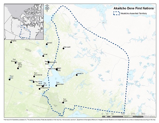
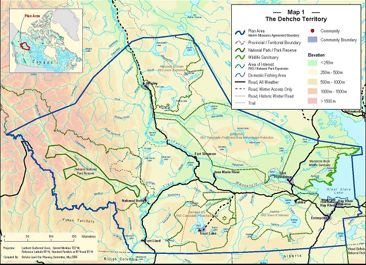
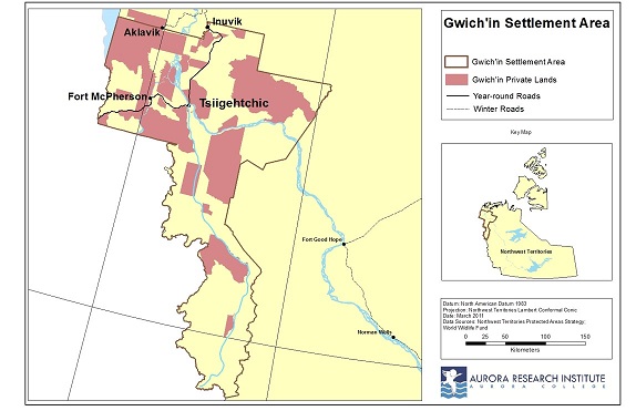
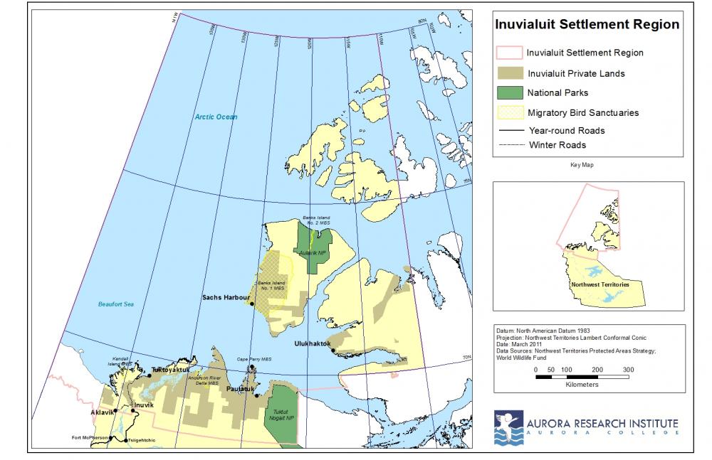
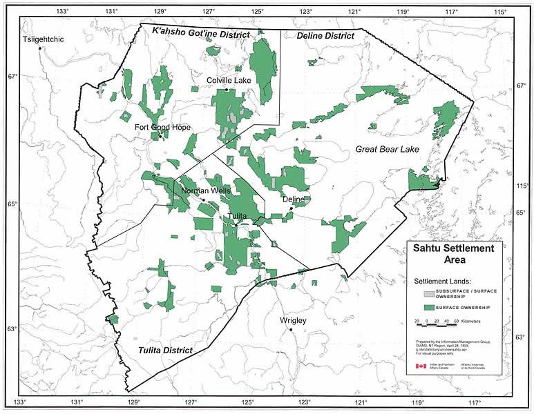
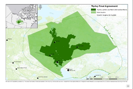
Slavey Indians Territory extended from western Hudson Bay to most of north Manitoba, all of north Saskatchewan, nearly all of north Alberta and nearly all of north British Columbia. All of Northwest Territories is Slavey Indians Territory. Much of Nunavut is Chipewyan Territory. Parts of Yukon and parts of Alaska are also Chipewyan Territory. At this time Chipewyan People have large Territories in Alberta and British Columbia. Akaitcho Territory (it's located mainly in Northwest Territories with a smaller area in Nunavut and an even smaller area located in northeast Alberta) covers 480,000 sq. km. or 185,329 sq. mi. It's Chipewyan Peoples largest territory. Dehcho Territory (South Slavey People who are really Chipewyan) covers 215,000 sq. km. or 83,011 sq. mi. We will not recognize any agreement that reduces these Chipewyan Territories of Akaitcho and Decho sizes and if mixed bloods are allowed to sign agreements. Tlicho Settlement Region (Dogrib People who are also Chipewyan) was reduced to a territory of 39,000 sq. km. or 15,100 sq. mi. on August 25, 2003. It's in compact form which means it's legitimate. Sahtu Settlement Region (North Slavey People who are really Chipewyan) was reduced to 41,437 sq. km. or 15,999 sq. mi. on September 6, 1993. However, their land is not in compact form which means it's fraudulent or Canada did not deal with them on a nation to nation level. It's also fraudulent because Canada allowed mixed bloods to sign agreements. Canada also bought their leaders to not protest. Gwich'in Settlement Region or Territory, was reduced to 23,976 sq. km. or 9,257 sq. mi. However, their land is not in compact form which means it's fraudulent or Canada did not deal with them on a nation to nation level. Most of Gwich'in land is in Northwest Territories, with a very small area located in Yukon. Canada also bought their leaders to not protest. Inuvialuit Settlement Region or territory, was 435,000 sq. km. or 168,000 sq. mi. After reaching an agreement on July 25, 1984, they were left with 90,600 sq. km. or 34,981 sq. mi. Nearly all is in compact form. Canada also bought their leaders to not protest. However, Inuvialuit People are foreigners. That land rightfully belongs to Chipewyan People. Inuvialuit Settlement Region Agreement is invalid because Eskimos or Inuit People are not native to these America's. They were brought over to North America, from Asia, by Russians.
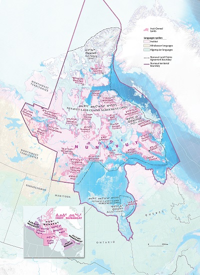
Canada didn't bother including Chipewyan People or Ojibway People, in Nunavut's Land Claims Agreement. It was signed on May 25, 1993 at Iqaluit. At that time (May 25, 1993) what is now Nunavut, was a part of Northwest Territories. Eskimos or Inuit People are not native to these America's. Before Eskimos were brought to North America by Russians, Ojibway People were living throughout what is now Nunavut, especially central and north Nunavut. They invented Kayaks and were somewhat civilized. Inuit People were giving 350,000 sq. km. or 140,000 sq. mi. of land. Canada also paid Inuit leaders over $1.9 billion to not protest. Canada did not bother consulting with Chipewyan leaders. They earlier in 20th century and probably late 19th century, forced Ojibway People living in Nunavut's interior, to relocate to villages along Beaufort Sea and Hudson Bay. We do not recognize May 25, 1993's Nunavut Land Claims Agreement. It's fraudulent. You have to consult with Ojibway Nation. Therefore, all of Nunavut remains Ojibway Land.
