Ojibwa AI Videos ___ Walmart ___ Amazon
Ojibwa Prophesy ____ Ebay ______ TV Playlists
Montana Ojibwe Reservations and their Communities Book
Minnesota Ojibwe Reservations and their Communities Book
Place Names of the Ojibwa in Future Codes Book

Anishinabe History
Ojibwa AI Videos ___ Walmart ___ Amazon
Ojibwa Prophesy ____ Ebay ______ TV Playlists
Montana Ojibwe Reservations and their Communities Book
Minnesota Ojibwe Reservations and their Communities Book
Place Names of the Ojibwa in Future Codes Book
Jocko Reservation of Montana
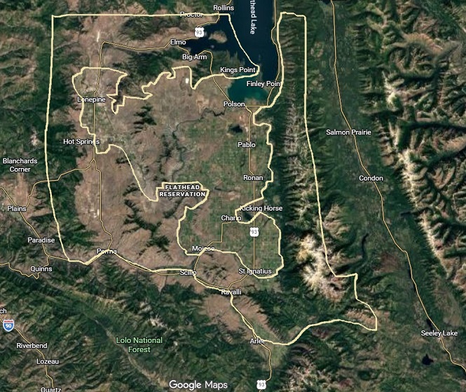
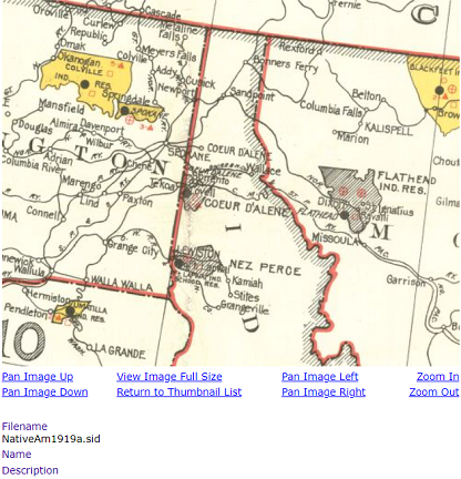
According to 2020's census, Jocko Reservation of Montana has the largest Ojibwa population of any Ojibwa Reservation at Montana. It is 7,076. Including mixed bloods it's 10,293. Including Mexicans it's 11,901. However, total population of Jocko Reservation is 32,167. Whites account for two thirds of the population. However, Jocko Reservation is smaller and we can't obtain it's correct demographics. That includes the native language which is corrupted. More about that follows. Below are links to google earth photos of Old Agency (you'll notice remains of buildings that were demolished after Pablo became Jocko Reservations new agency) and other Jocko Reservation native communities. A map of Jocko Reservation can't be included because we don't know the correct boundaries of Jocko Reservation. You'll learn more about that after reading Jocko Reservations history concerning chief Rocky Boy. Pablo is a white town. It was established during the allotment era. Jocko Reservations agency was located at Old Agency until the 1960's when a decision was made to relocate the agency to Pablo which was predominantly white during those times. Old Agency had a larger population when it was agency of Jocko Reservation. Since the agency relocation the population of Old Agency has decreased. Jocko Reservation history is corrupted. Also known as Flathead Reservation, it's correct name is Jocko Reservation. It was named after an Ojibwa fur trader who worked for European Trade Posts. One was controlled by HBC or Hudson Bay Company. Jocko Reservation is within the Ojibwa "Chosen Land." Pertaining to it's history, Jocko Reservation was supposedly set aside on July 16, 1855. That's deceiving however. This predicament deals with our "Chosen Land." American leaders had difficulties moving Ojibwa People to Jocko Reservation (aka Flathead Reservation) early on. In fact, American leaders refused to set aside a Reservation within Mission Valley because of abundant farmland. People living at Jocko Reservation think it's a former Reservation. Below is a 1919 map that shows Jocko Reservation being a former Reservation. They are wrong! More about that is included with chief Rocky Boys history. Flathead Reservation is actually located at the Great Falls, Montana region where there are many flat top shaped mountains.
Chief Rocky Boy was set aside a compact form Reservation within Jocko Reservation on January 8, 1904 which means there's a large area within Jocko Reservation that is predominantly Ojibwa. We don't know where the new diminished in size Jocko Reservation is however. Chief Rocky Boy had to negotiate with American leaders who violated our "Chosen Land." Senator Gibson (he along with Robert Vaughn founded Great Falls) created a bill which American leaders passed (they did not reject it) on January 8, 1904. His bill was actually an agreement he reached with chief Rocky Boy about Jocko Reservation that became affective a few months later on April 23, 1904. It's known as Flathead Reservation Land Act. Well being of his Ojibwa Subjects forced chief Rocky Boy to accept Flathead Reservation Land Act. Most of his Ojibwa Subjects were in favor of accepting land allotments. Chief Rocky Boys new diminished in size Jocko Reservation was set aside in compact form on January 8, 1904. Below is a news article from a January 1904 The River Press Newspaper, detailing Senator Gibson's Bill! Senator Gibson was instrumental in helping chief Rocky Boy. Ojibwa's living at Jocko Reservation know nothing about chief Rocky Boy. Finding chief Rocky Boy's Jocko Reservation is very difficult. Finding chief Rocky Boy's Reservation within Blackfeet Reservation is easier. Blackfeet Reservation was not opened to white settlement or did not have surplus land after land allotments. Using google earth is helpful. Woodlands were allotted to individual Ojibwa's, as well as wetlands and, of course, the mountains continue to belong to Jocko Reservation. Natives of Jocko Reservation refer to themselves as three tribes. They really mean three Reservations. They forgot about that long ago. Coeur d'Alene Reservation, Jocko Reservation and Spokane Reservation. We will refer to them as our "Chosen Land." All of western Montana (from Musselshell River to the Idaho/Montana border), north Idaho, much of Washington (from the Idaho/Washington border to Pacific Ocean north of Seattle) and parts of extreme north Oregon is within our "Chosen Land," which was violated by Americans leaders.
After allotments were issued, what remained after allotments were issued became surplus land. Unlike Blackfeet Reservation which had no surplus land after land allotments were issued, Coeur d'Alene Reservation, Jocko Reservation and Spokane Reservation had surplus land after land allotments were issued. On May 22, 1909, Coeur d'Alene Reservation, Jocko Reservation and Spokane Reservation ceded their surplus land to the United States. That proves Coeur d'Alene Reservation and Spokane Reservation were a part of April 23, 1904's Flathead Reservations Land Act. Spokane Reservation had little farmland. Less than 6,000 acres was deemed surplus land and was ceded by Spokane Reservation to the United States on May 22, 1909. Nearly all of the west portion of Coeur d'Alene Reservation was deemed farm land which became surplus land. It was ceded to the United States on May 22, 1909. Jocko Reservation is a predicament because we don't know exactly how much land was considered surplus land. It's obvious that most of Mission Valley and Jocko Valley became surplus land. Both regions have much farmland. At Mission Valley are locations where large areas of woodlands and wetlands are. Jocko Reservations west portion is the location where most Ojibwa's were issued land allotments. It's also where Old Agency is! Many Ojibwa's were issued land allotments at Mission Valley. At Jocko Valley land allotments were issued adjacent to and north of Jocko River. After land allotments were issued in compact form (by way of mountains and Flathead Lake) what remained became surplus land. It was ceded on May 22, 1909. Average allotment size was from 40 acres to 60 acres. Supposedly over 200,000 acres was given to over 2,000 Ojibwa's. American leaders did not honor agreements they reached with chief Rocky Boy who agreed to allow land allotments as long as if they were in compact form and could not be sold. American leaders allowed the allotments to be sold which is illegal. They betrayed chief Rocky Boy. They constantly betrayed chief Rocky Boy.
January 8, 1904: Bill passed to create Flathead Reservation Allotment Act. Senator Gibson's bill also included Coeur d'Alene Reservation and Spokane Reservation. Congressman Dixon had nothing to do with the bill other than support the bill. Senator Gibson who was from Great Falls, is responsible for the bill. Their objective was to allot land at Jocko Reservation for Ojibwa's who lived at Jocko Reservation and the Great Falls region. Senator Dixon tried supporting chief Rocky Boy in 1908 yet American leaders ignored him.
April 23, 1904: Flathead Reservation Allotment Act became official. Chief Rocky Boy was forced (he did not want to allow allotments) to prepare those of his Ojibwa's Subjects who lived at Jocko Reservation for accepting land allotments in compact form that became the new smaller Jocko Reservation. Chief Rocky Boy was also forced to prepare Ojibwa's from the Great Falls region who were in favor of accepting land allotments, for relocations to Coeur d'Alene Reservation, Jocko Reservation and Spokane Reservation. Each Reservation was targeted by April 23, 1904's Allotment Act.
Over 61,000 acres was illegally taken from Jocko Reservation to become Montana State School Land. The land continues to be owned by Jocko Reservation.
1908: Chief Rocky Boy dealt with extreme hostile American actions. In early 1908, they destroyed most of his Reservations agency (St. Peters Mission) which was located about 25 miles southwest of Great Falls. In October 1908, Swan Valley Massacre forced chief Rocky Boy to prepare his Ojibwa Subjects for land allotments and forced relocations. Up to 250,000 acres was allotted to over 2,000 Ojibwa's at Jocko Reservation. Correct number may have been close to 5,000.
Another 2,524.7 acres or 1,021.7 hectares was set aside for tribal use by April 23, 1904's Allotment Act.
Another 6,774.92 acres or 2,741.7 hectares was set aside for agency purposes by April 23, 1904's Allotment Act.
Another 18,521.35 acres or 7,495.3 hectares was set aside for a bison range on May 23, 1908.
April 12, 1910: Another 45,714 acres or 18,499.8 hectares was reserved for power and Reservoir sites.
1920: This following information is possibly incorrect. An estimated 124,795 acres was allotted to an unknown number of Ojibwa's. The land was probably illegally taken from Jocko Reservation or taken without consent. It deals with chief Rocky Boys 1913 agreement to withdraw Ojibwa Soldiers from the Mexican Revolution. By 1920, the Mexican Revolution was near over. American leaders betrayed chief Rocky Boy again!
Land Area: Allotted land and protected land 486,445 acres. Much if not most of the allotments in compact form, were illegally sold. Including mountains the land area of the new smaller Jocko Reservation is close to 1,200 sq. mi. or near 800,000 acres. We don't know where the new smaller Jocko Reservation is nor the correct demographics of the new smaller Jocko Reservation. American leaders will not allow it. After allotments the surplus land was ceded to the United States. About 40% of the original Jocko Reservation was ceded. It's no longer a part of Jocko Reservation.
Chief Rocky Boys Jocko Reservation is likely located from Jocko Rivers source to it's mouth at Flathead River. From Jocko Rivers mouth at Flathead River the southwest boundary of chief Rocky Boys Jocko Reservation follows Flathead River west to where it leaves Jocko Reservation on the southwest. We can't include land south of Flathead River at that location because of Senator Dixon. He tried to help chief Rocky Boy. Dixon, Montana is located about 1 mile southwest of Old Agency. Where Jocko Rivers mouth is at Flathead River it follows Flathead River north to where Little Bitterroot Rivers mouth is at Flathead River. It follows Little Bitterroot River to where Hot Springs Creeks mouth is at Little Bitterroot River. It follows Hot Springs Creek west to Highway 28 which is near where Jocko Reservations west mountains are. It follows the west slopes of Jocko Reservations west mountains near Highway 28 to where Highway 28 makes an abrupt turn east to Elmo. The boundary then extends east to just north of Rocky Point and then Flathead lake. National Bison Range is within chief Rocky Boys Jocko Reservation. At Mission Creeks mouth (possible original location of Jocko Reservations first agency) the boundary follows Mission Creek east to Mission Reservoir. All land south of Mission Creek is within chief Rocky Boys Jocko Reservation. All land adjancent to Mission Mountains are within chief Rocky Boys Jocko Reservation. Isolated regions west of Mission Mountains are within chief Rocky Boys Jocko Reservation including the region east, north, south and west of Kicking Horse Reservoir and Ninepipe Reservoir. That area is largely wetlands. The region east, southeast and northeast of Ronan to Mission Mountains. It's woodlands. The region from just west of Turtle Lake to Mission Mountains. It's largely woodlands. It's possible they allotted over 200,000 acres throughout the regions described. Part of St. Ignatius town adjacent to and south of Mission Creek is within chief Rocky Boys Jocko Reservation. Leaders of Jocko Reservation will reject it! However, the Rocky Boy Tribe will recognize it! I know Jocko Reservation leaders are very angry. Don't Ever Blame Me! I mean it! Your hostility is getting you into trouble with non whites from far in the future. I won't forget how hostile you were towards me. Since you won't look out for your subjects best interests, we will!
Very little farmland was allotted to Ojibwa's. What land was allotted to them that can be classified as agriculture land is located south of Mission Creek and north of Jocko River. Another area is the location from Flathead River to Hot Springs Creek. Most of their land allotments can be described as land suited for cattle raising. American leaders refused to honor agreements and allowed Ojibwa's to sell their land allotments. Chief Rocky Boy did not agree to that when negotiations were conducted. Jocko Reservation was a dumping ground for land allotments. Several forced relocations of Ojibwa's took place between 1890 up to 1915. Though the map I drew might not be the correct diminished in size Jocko Reservation, I suspect it's close to being correct. I would estimate that 35% to 40% of Jocko Reservation was deemed surplus land and was ceded on May 22, 1909. They will not allow natives to know where the surplus land was located nor where their compact form Jocko Reservation is.
Big Arm Satellite Image
Big Arm Road View
Big Arm Road View
Big Arm Road View
Big Arm Road View
Big Arm Road View
Big Arm Road View
Big Arm Road View
Big Arm Road View
Clarice Paul Homesite Satellite Image
Clarice Paul Homesite Road View
Clarice Paul Homesite Road View
Clarice Paul Homesite Road View
Clarice Paul Homesite Road View
Clarice Paul Homesite Road View
Clarice Paul Homesite Road View
Clarice Paul Homesite Road View
Elmo Satellite Image
Elmo Road View
Elmo Road View
Elmo Road View
Elmo Road View
Elmo Road View
Elmo Road View
Elmo Road View
Elmo Road View
Elmo Road View
Mission Homesite Satellite Image
Mission Homesite Road View
Mission Homesite Road View
Mission Homesite Road View
Mission Homesite Road View
Mission Homesite Road View
Mission Homesite Road View
Old Agency Satellite Image
Old Agency Satellite Image
Old Agency Satellite Image
Old Agency Satellite Image
Old Agency Road View
Old Agency Road View
Old Agency Road View
Old Agency Road View
Old Agency Road View
St. Ignatius Satellite Image
St. Ignatius Road View
St. Ignatius Road View
St. Ignatius Road View
St. Ignatius Road View
St. Ignatius Road View
St. Ignatius Road View
St. Ignatius Road View
Turtle Lake Satellite Image
Turtle Lake Road View
Turtle Lake Road View
Turtle Lake Road View
Turtle Lake Road View
Turtle Lake Road View
Turtle Lake Road View
Turtle Lake Road View
Turtle Lake Road View
Woodcock Homesite Satellite Image
Woodcock Homesite Road View
Woodcock Homesite Road View
Woodcock Homesite Road View
Woodcock Homesite Road View
Woodcock Homesite Road View
Woodcock Homesite Road View
Woodcock Homesite Road View