Ojibwa AI Videos ___ Walmart ___ Amazon
Ojibwa Prophesy ____ Ebay ______ TV Playlists
Montana Ojibwe Reservations and their Communities Book
Minnesota Ojibwe Reservations and their Communities Book
Place Names of the Ojibwa in Future Codes Book

Anishinabe History
Ojibwa AI Videos ___ Walmart ___ Amazon
Ojibwa Prophesy ____ Ebay ______ TV Playlists
Montana Ojibwe Reservations and their Communities Book
Minnesota Ojibwe Reservations and their Communities Book
Place Names of the Ojibwa in Future Codes Book
Mishi Madaogiwining Ojibwa Reserve
We will trace the origins of vast Mishi Madaogowining Ojibwa Reserve to Treaty 5 and Treaty 9. The treaty signings of 1929/1930 are not adhesions to Treaty 9. It's a new treaty. Treaty 5 Text commences with incidents on September 20, 1875 and September 24, 1875. At Berens River on September 20, 1875 and at Norway House on September 24, 1875, treaty signings took place which don't agree. Either you consider the mouth of Saskatchewan River to be located at Grand Rapids, Manitoba or at York Factory, Manitoba. Both can be used. Every treaty authentic Ojibwa leaders signed with Canada and England are invalid. Why? Treaties involving land cessions are made between two nations. They are not made between one nation and one person! There is no such nation as Canada! All treaties between Ojibwa Nation and England and Canada must be corrected or the United States must take control of Canada and sign new treaties with Ojibwa Nation that legally cedes land and set's aside vast (in the 100,000's of sq. mi.) Ojibwa Reserves. We must reject all treaties between Ojibwa Nation and Canada and England and honor 1701's Treaty that ceased the Beaver Wars. We also must continue to recognize the Italian Colony of Quebec and possibly the Dutch Colony and Colony of Ireland. However, both the Dutch Colony and Colony of Ireland were eradicated in 1763/1764. Boundaries of Quebec Colony extend from the mouth of Oswego River at Lake Ontario, then to the mouth of Seneca River, then to Onondaga Lake, then east to the west boundary of old Dutch Colony. Following the west boundary of old Dutch Colony, it extends to the mouth of Mohawk River. It then extends straight east to Merrimack River and follows Merrimack River to the Atlantic Ocean. Part of northeast Massachusetts is a part of Quebec Colony. Per 1701's Treaty Agreements Ojibwa leaders Reserved for Ojibwa People and other natives much land east of the Appalachian Mountains. Around 1700, leaders of Quebec Colony requested for treaty and Ojibwa leaders agreed. Both Ojibwa leaders and Italian leaders of Quebec Colony met at an Italian Fort adjacent to Mohawk River (at or near what is now Rome, New York) and agreed the constant wars needed to cease. They formally signed treaty in 1701 at Montreal. To educate you about treaties involving land cessions between two nations the following information is included:
Treaty 5 between Her Majesty the Queen and the Saulteaux and Swampy Cree Tribes of Indians at Beren's River and Norway House with Adhesions
Treaty no. 5
ARTICLES OF A TREATY made and concluded at Beren's River the 20th day of September, and at Norway House the 24th day of September, in the year of Our Lord one thousand eight hundred and seventy-five, between "Her Most Gracious Majesty the Queen" of Great Britain and Ireland, by Her Commissioners the Honourable Alexander Morris, Lieutenant-Governor of the Province of Manitoba and the North-west Territories, and the Honourable James McKay, of the one part, and the Saulteaux and Swampy Cree tribes of Indians, inhabitants of the country within the limits hereinafter defined and described, by their Chiefs, chosen and named as hereinafter mentioned, of the other part.
Commencing at the north corner or junction of Treaties Nos. 1 and 3; then easterly along the boundary of Treaty No. 3 to the "Height of Land," at the northeast corner of the said treaty limits, a point dividing the waters of the Albany and Winnipeg Rivers; thence due north along the said "Height of Land " to a point intersected by the 53 degrees of north latitude; and thence north-westerly to "Favourable Lake"; thence following the east shore of said lake to its northern limit; thence north-westerly to the north end of Lake Winnipegoosis; then westerly to the "Height of Land" called "Robinson's Portage"; thence north-westerly to the east end of "Cross Lake"; thence north-westerly crossing "Foxes Lake"; thence north-westerly to the north end of "Split Lake"; thence south-westerly to "Pipestone Lake," on "Burntwood River "; thence south-westerly to the western point of "John Scott's Lake"; thence south-westerly to the north shore of "Beaver Lake"; thence south-westerly to the west end of "Cumberland Lake"; thence due south to the "Saskatchewan River"; thence due south to the north-west corner of the northern limits of Treaty No. 4, including all territory within the said limits, and all islands on all lakes within the said limits, as above described; and it being also understood that in all cases where lakes form the treaty limits, ten miles from the shore of the lake should be included in the treaty.
And also all their rights, titles and privileges whatsoever to all other lands wherever situated in the North-west Territories or in any other Province or portion of Her Majesty's dominions situated and being within the Dominion of Canada;
The tract comprised within the lines above described, embracing an area of one hundred thousand square miles, be the same more or less;
To have and to hold the same to Her Majesty the Queen, and Her successors forever;
All treaties made between Ojibwa Nation and Canada and England are invalid! No authentic Ojibwa leaders showed up at treaty signings because their law forbid them to sign treaty with one person. If land cessions were involved the nations involved selected a treaty signing location and had their negotiators negotiate terms of treaty agreements. An authentic Ojibwa Treaty is below:
TREATY WITH THE CHIPPEWA-RED LAKE AND PEMBINA BANDS, 1863.
Articles of a treaty made and concluded at the Old Crossing of Red Lake River, in the state of Minnesota, on the second day of October, in the year eighteen hundred and sixty-three, between the United States of America, by their commissioners, Alexander Ramsey and Ashley C. Morrill, agent for the Chippewa Indians, and the Red Lake and Pembina bands of Chippewas; by their chiefs, head-men, and warriors.
It's an authentic treaty except the information including soldiers. Ojibwa Soldiers would not sign treaty because their Military and Police Totem had leaders who had authority to sign treaties. Ojibwa Soldiers had no authority to sign treaties. A probable error in translation took place. Instead of writing "warriors," the rank of the Ojibwa Military leaders should have been written. We know the Ojibwa Military and Police Totem signed October 2, 1863's Old Crossing Treaty.
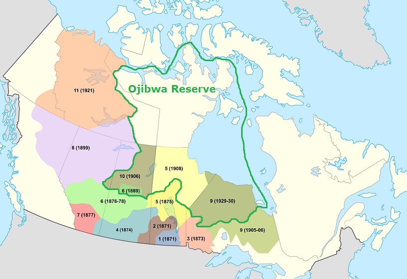
In 1929, it had been nearly 55 years years since Treaty 5 signings commenced in 1875. Many Ojibwa Folks who were in their 20's, 30's and 40's in 1875, did recollect the correct Treaty 5 Ojibwa leaders signed on September 27, 1875! Though English negotiators wrote the September 27, 1875 Treaty signing took place at Grand Rapids, we know it took place at York Factory. Ojibwa leaders selected land they knew white leaders rejected. Land north and south of Saskatchewan River was involved. Waterways included in 1929 and 1930's treaty signings include the following:
Saskatchewan River (aka Nelson River) Band:
Saskatchewan River commences at the Rocky Mountains far west of York Factory. It's known as North Saskatchwan River from it's source at the Rocky Mountains a few miles northwest of Saskatchewan River Crossing or just south of Mt. Athabasca. Ojibwa's knew this river extremely well and considered it's mouth to be located at Hudson Bay or where Port Nelson and York Factory are. Using their canoes they sailed down river to where the mouth is or where Port Nelson and York Factory are. Saskatchewan River Ojibwa's named the river after it's current. Ojibwa word for current is "ji-wan." Some dialects pronounce it "chi-wan." There's two known pronunciations. One is "Shi-ka Ji-wan." The other "Shi-kat Chi-wan." Notice there's a 't' in Saskatchwan and no 'd or t' in Shikajiwan? At wikipedia they wrote it's derived from "ki-sis-kat-chi-wan." According to them it's definition is "Swift Flowing River." Old Ojibwa Language Dictionaries confuse readers by spelling it "Ki-jid-ji-wan." It's not pronounced "Key-jid Ji-wan." It's pronounced "Key-shid Ji-wan." It's an insult. Definition of "Key-shid Ji-wan" is "There is a Rapid or There are Rapids." Both are incorrect. Definition of Saskatchiwan is "Quick Current River." Ojibwa Language word for quick is "kijika." It has been deliberately corrupted. It's correct pronunciation is "Key-shi-ka." Thus, it becomes "Key-shi-kad Ji-wan. Translation is "Quick Current." Baraga deliberately corrupted Ojibwa Language. Instead of writing "I Quick or Nin Kijika" he wrote "I Walk Quick or Nin Kijika." He refused to provide a proper definition for the word "quick." Anyone trying to learn Ojibwa Language will become frustrated because of all the violations Baraga wrote. Correct Ojibwa Language word for 'quick' is obviously "kijika." A 'd ot t' must be placed before the "ji" to let learners know it's pronounced like the letter 'g' and not 'zhi.' Correct pronunciation is "Key-shi-kad Ji-wan." Other Ojibwa Language Dialects it's "Key-shi-kat Chi-wan." Ojibwa's named the waterway "Key-shi-kat Chi-wan Sip-pi." Quick Current River! Most used "Key-shi-kad Ji-wan or Shi-kad Ji-wan" because of it's softer sound. Somehow the "ki or key" was excluded and only "Shi-kat Chi-wan" used. And if you happen to be confused about the "tchi," it must be written that way. The "ji" in Ojibwa Language is either pronounced like the letter 'g' or like 'zhi.'
From Norway House to York Factory are several Northern Ojibwa Communities identified as Saskatchewan River Ojibwa's. They're Cross Lake, Fox Lake, Norway House, War Lake (aka Ilford) and York Factory or York Landing. All are from the York Factory Band. As a result of the War of 1812, Ojibwa leaders agreed to allow Red River Colony to exist. Chief Peguis later regretted doing so. As part of the War of 1812's Peace Agreements, Red River Colony was allowed access to Saskatchewan River (aka Nelson River) and to establish HBC Trade Posts. As a result, Ojibwa's who lived along the stretch of Saskatchewan River (aka Nelson River) from Norway House to Port Nelson and York Factory became lawless or rejected the Ojibwa Totemic System that governed Ojibwa People. Ojibwa's considered them traitors!
Hayes River Band:
Domain of Hayes River Ojibwa's is located from Sachigo River (aka Severn River) at northwest Ontario to Hayes River at northeast Manitoba. Hayes River flows from it's source at Molson Lake down river to it's mouth at Hudson Bay where Port Nelson and York Factory are. Included as the Hayes River Band of Ojibwa's are Manto Sakahigan, Manto Sipi, Norway House, Oxford House and Shamattawa. It's thought Shamattawa Ojibwa's signed Treaty 5 in 1910 as the York Factory Band. However, Shamattawa Ojibwa's did not consider themselves Saskatchewan River (aka Nelson River) Ojibwa's. Consideration of Hayes River and it's tributaries was how they named their district. All Hayes River Ojibwa's signed Treaty 9 in 1929. Hayes River Band of Ojibwa's waterways include Hayes River from it's source at Molson Lake then to Oxford House then to Hudson Bay. Norway House and Oxford House belong to main Hayes River. Where it branches then leads to Shamattawa is East Branch Hayes River. Shamattawa belongs to East Branch Hayes River. Where East Branch Hayes River branches at Shamattawa, Southeast Branch of Hayes River leads to Manto Sakahigan, Manto Sipi and Island Lake which is directly connected to Hayes River yet we must reject Island Lake because they've openly admitted that they're foreigners. Not only have they admitted they're foreigners they also insulted Ojibwa People! The Hayes River Band of Ojibwa's have foreigners living on their domain. Those foreigners also settled at Deer Lake and Sandy Lake at northwest Ontario. Manto Sakahigan, Manto Sipi, Norway House, Oxford House and Shamattawa are Hayes River Band of Northern Ojibwa's. And Island Lake and Sandy Lake belong to Haye's River Band of Ojibwa's yet foreigners live at those locations. Below is a excerpt from an article about the Island Lake Foreigners admitting that they're foreigners and insulting Ojibwa People. From Island Lake where they settled from some unknown foriegn location, they did sneak their way to Deer Lake, North Spirit Lake and Sandy Lake and settled. It's not known how many of chief Rocky Boys Montana Ojibwa Subjects were relocated to the Island Lake region during 1909 and after!
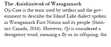
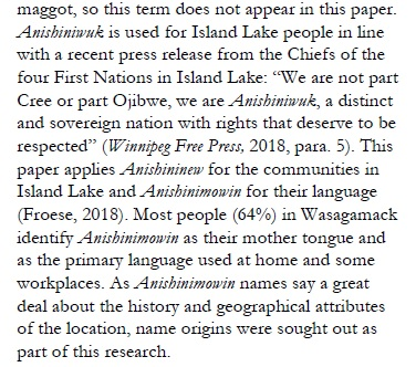
During 1929/1930 Canada negotiated a new treaty (historians claim it was adhesion signings to 1905-1906's Treaty 9) with Ojibwa's living from Attawapiskat to northeast Manitoba. We'll identify the isolated Ojibwa's from Fort Albany to northeast Manitoba as Shamattawa. HBC (Hudson Bay Company) identified an Ojibwa People they named "Shu-ma-ta-way." They lived from Albany River to Nelson River (it was really up to the Arctic Ocean) who were hostile towards them and their Inuit allies and idiotic Ojibwa allies. Instead of settling near European Forts, they confined themselves inland and controlled all waterways. HBC Forts did lure idiotic Ojibwa's to them by using alcohol and drugs (opium) yet the great majority confined themselves inland. Those idiotic Ojibwa's who were lured became addicts and lived at or near European Forts and Trade Posts. Many became "Carriers" who were supplied with European trade goods (most was alcohol and opium) to use to lure in unsuspecting Ojibwa's. HBC Staff named them "Homeguard Cree." Other names they called them were Cree, Keskatchewan and the Beaver Tribe. For educational reasons we'll identify them as the "Carrier Tribe." Ojibwa Soldiers had to battle them and eventually forced them to central British Columbia. By late 19th century, northern Ojibwa's living at the interior of northeast Manitoba and north Ontario, did often trade with trade posts. However, they were not willing to live like Europeans. A vast area of land of perhaps over 200,000 sq. mi. allowed them to continue to live as their ancestors did. They continue to consider that vast land area their land!
Sachigo River Band:
At northwest Ontario we'll identify Sachigo River (aka Severn River) as being Sachigo River Ojibwa Territory. Different from the Saskatchewan River (aka Nelson River) Band Ojibwa's who were forced to alter their way of life by relocating to sites where dams were constructed and Thompson, Manitoba, Northern Ojibwa's (Shamattawa Ojibwa's or Nekawawuck Ojibwa's) continued to subsist as their ancestors did well into the 20th century. Even now many continue to fish, hunt and trap throughout their vast domain. However, their many small villages scattered throughout their vast domain were abandoned and "they," forced to reside where they live now. Before that took place they dealt with little crime. Now they deal with crime on a level they rather ignore yet can't. And many of their children are sent to white communities far from them to obtain an education. Sachigo River Tributaries during the 20th century had many small Ojibwa villages. Canada broke treaty so they could confine Northern Ojibwa's where they now live. Treaty agreements permitted Northern Ojibwa's to fish, hunt and Trap where they wanted or they had control of all fishing, hunting and trapping. Included along with the Sachigo River (aka Severn River) Ojibwa's are Windigo River Ojibwa's who are the North Caribou Lake Ojibwa's. On July 18, 1930 the Windigo River (it's a tributary of Sachigo River) Ojibwa's signed Treaty 9. And the Shamattawa or Hayes River Ojibwa's obviously signed the July 5, 1929 Treaty at Big Trout Lake. Residents of Shamattawa consider Sachigo River (aka Severn River) their east boundary.
Winisk River Band:
At north Ontario we'll identify Winisk River as being Winisk River Ojibwa Territory. HBC Staff were aware of Winisk River Ojibwa's and of two different groups of Winisk River Ojibwa's. One group of Winisk River Ojibwa's was much smaller and confined themselves at or near European Forts and Trade Posts. Often they ventured inland to trap for HBC yet doing that was extremely dangerous because Winisk River Ojibwa's who confined themselves inland considered them traitors as they considered the Inuit. HBC Staff had difficulties with Northern Ojibwa's who settled at or near their forts and trade posts. Ojibwa resentment against Inuit People was intense which caused HBC Staff to constantly warn their idiotic Ojibwa allies to leave Inuit People alone. Use of threats of no alcohol and opium usually kept their Northern Ojibwa allies under their control from Fort Albany to Fort Churchill. If an HBC Fort or Trade Post was out of supplies of alcohol and opium, they had to deal with extremely enraged and dangerous Northern Ojibwa's in need of alcohol and opium. Ojibwa's of the interior were not at all content with the damage caused by HBC. Civil War among Ojibwa People was a strategy Europeans instigated after invading the America's. To instigate civil war among Ojibwa People Europeans used alcohol and drugs. Authentic Ojibwa leaders always complained about that predicament. Winisk River Band of Ojibwa's signed Treaty 9 with Attawapiskat River Ojibwa's.
Attawapiskat River Band:
At the west shores of James Bay we'll identify Attawapiskat River as being Attawapiskat River Ojibwa Territory. Between Attawapiskat River and Winisk River a smaller Ojibwa Population lived a primitive life to an extent. They also had to allow their children to attend European controlled boarding schools where Ojibwa Children were forced to stop speaking Ojibwa and learn to live a corrupted way of life that their parents were most certainly against. Canada had an easier time altering the way of life of Ojibwa People between Nelson River and Sachigo River than between Attawapiskat River and Winisk River. The region between Manto Sakahigan and Nelson River to Hudson Bay had a larger Ojibwa Population during the early 20th century. After 1950, the Ojibwa Population of that location was relocated or greatly reduced. A better way of life was promoted and too many Ojibwa's were lured away from their Reserve to gain a better way of life. Far too many were lured to alcohol and drug use and prisons. All the small Ojibwa villages were abandoned with the Ojibwa's who lived at them finding other Reserves to live at. Living among their own folk was law to them! Attawapiskat River Ojibwa's proved more difficult to persuade to alter their lifestyle. Being very content to live along Attawapiskat River and it's tributaries kept them more at ease. In the late 19th century, an HBC Trade Post was established at the mouth of Attawapiskat River to lure Attawapiskat River Ojibwa's to so they would settle there. Few Attawapiskat River Ojibwa's settled at and near the HBC Trade Post however. That changed during the mid 20th century. By the late 1960's nearly all had relocated to Attawapiskat Town. However, some of the elders continue to live well inland and only visit Attawapiskat during a few days each December. During the 1950's tents were used as housing at Attawapiskat then permanent dwellings were constructed in the 1960's and 1970's. So the transition from living far inland to where Attawapiskat Town is was indeed slow. Most Ojibwa's of Attawapiskat River were not attracted to the coast of James Bay. Summers were cooler and flooding frequent where Attawapiskat Town is. Further inland summers are warmer by 3 degrees to 5 degrees. James Bay has an influence on climate conditions similar to Hudson Bay. On the whole, Northern Ojibwa's confined themselves well inland along important waterways. In the case of Attawapiskat River Ojibwa's they lived as far west as Neskantaga where Attawapiskat Lake is. It's the source of Attawapiskat River! At Wikipedia's Attawapiskat First Nation page they claim they lived as far inland as Lake Missisa. They're off by over 100 miles. History indicates Ojibwa's had no permanent settlement where Attawapiskat Town is. Flooding prevented them from creating a permanent settlement there. Only on occasions did they visit the mouth of Attawapiskat River to visit and fish and hunt.
They have not forgot about their vast Reserve. It's knowledge that's been kept and honered. From Attawapiskat to Shamattawa they'll tell you all the surrounding land is theirs because it is. During 1929 and 1930, their vast "Mishi Madaogiwining Ojibwa Reserve" was created. And they continue to honor treaty. Canada does not. At Big Trout Lake on July 5, 1929 negotiations for the vast Ojibwa Reserve commenced. On July 18, 1930 the Windigo River Ojibwa's signed the treaty. On July 28, 1930 the Attawapiskat River Ojibwa's and Winisk River Ojibwa's signed the treaty. Fort Severn was an obvious diversion. Ojibwa's living along Sachigo River (aka Severn River) signed the July 5, 1929 Treaty at Big Trout Lake. Among the Sachigo River Ojibwa's who signed the July 5, 1929 Treaty were the York Factory Band or Shamattawa Ojibwa's who claim that portion of vast "Mishi Madaogiwining Ojibwa Reserve" from Sachigo River to Angling Lake at Manitoba.
HBC (Hudson Bay Company) named Northern Ojibwa's Shumataway. They also had other names including "Nekawawuck." Origin of the name "Shamattawa" is from "Shumataway." The word for "scrape" in Ojibwa Language is "ma-da." It's from 'ma-da-i-ge-win.' I scrape it (either animate or inanimate) is "nin ma-da-an or nin ma-da-wa." Both 'an and wa' are used for composites or an additional word. Definition of "ma-da-wa" is scrape and scratch. However, there's another word used to identify distribution and repartition we must use. It's "madaokiwin." That's why Fort Severn must be excluded! Only York Factory had a population of Ojibwa's and Inuits. York Factory is on the border. According to 18th century HBC Staff, Shumataway Ojibwa's traded from Fort Albany to York Factory. A vast distribution area! We don't know what Shamattawa means! It certainly does not deal with rivers. It it did the word for river would be in it. Ojibwa locatives are "ang, ing and ong." Use of "mi-shi" is law. Definition of "mishi" is enormous, extensive, huge, immense, massive, vast, ect. Use of 'madaokiwin' is required. It's definition is "distribution" as we know. Since 'madaokiwin' means 'distribution' it's better to use 'madaokiwin' to identify a people. It's "Ma-da-o-gi-win'eeg." Translation is "Distribution People." Translation of "Mi-shi Ma-da-o-gi-win-eeg" is "Enormous Distribution People." For "Enormous Distribution Place" it's "Mi-shi Ma-da-o-gi-win-ing." Since the 18th century, Europeans have named northern Ojibwa's from Fort Albany to York Factory Shumataway. It's correct pronunciation is Shamattawa. And it deals with "distribution." It does not deal with confluences of rivers! We'll use "Mi-shi Ma-da-o-gi-win'ing" which means "Enormous Distribution Place." It does have music. Ojibwa Language is supposely a musical one! We can either include the Island Lake Ojibwa's with Mishi Madaogiwining Ojibwa Reserve or Misi Pawistik Ojibwa Reserve. Below is a list of communities of Mishi Madaogiwining Ojibwa Reserve:
Attawapiskat: (Treaty 9 on July 28, 1930 with Winisk River Ojibwa's)
Bearskin Lake: (Treaty 9 on July 5, 1929 with Big Trout Lake Ojibwa's)
Big Trout Lake: (Treaty 9 on July 5, 1929 - Possibly capital of Severn River Ojibwa's by way of Fawn River)
Deer Lake: (They're from Island Lake. They've agreed they're foreigners so the Rocky Boy Tribe will take claim - they were relocated from Montana to Island Lake around 1909/1910)
Fort Severn: (Treaty 9 on July 5, 1929 with Big Trout Lake Ojibwa's - they originally lived at the confluence of Sachigo River and Severn River which is 93 miles or 149 kilometers northeast of Big Trout Lake - another Treaty 9 adhesion signing took place at Fort Severn in 1930)
Fox Lake: (Affiliated with Shamattawa and though no evidence exist to confirm they signed Treaty 9 they were part of the York Factory Band)
Garden Hill: (They're from Island Lake. They've agreed they're foreigners so the Rocky Boy Tribe will take claim - they were relocated from Montana to Island Lake around 1909/1910)
Gillam: (Shamattawa leaders have to debate if they should include Gillam as a Shamattawa community - Gillam is now predominantly native and a Fox Lake community)
Kasabonika: (Treaty 9 on July 5, 1929 with Big Trout Lake Ojibwa's | July 28, 1930 at Winisk - They're a part of Winisk River Ojibwa's by way of Asheweig River)
Kingfisher: (Treaty 9 on July 5, 1929 with Big Trout Lake Ojibwa's | July 28, 1930 at Winisk - They're a part of Winisk River Ojibwa's by way of Asheweig River)
Manto Sakahigan: (Supposedly signed an adhesion to Treaty 5 on August 6, 1909 yet it was an adhesion to 1905/1906's Treaty 9)
Manto Sipi: (Supposedly signed an adhesion to Treaty 5 on August 6, 1909 yet it was an adhesion to 1905/1906's Treaty 9)
Muskrat Dam: (Treaty 9 on July 5, 1929 with Big Trout Lake Ojibwa's)
Neskantaga: (Supposedly signed Treaty 9 in 1906 yet they're Attawapiskat River Ojibwa's - Probably capital of Attawapiskat River Ojibwa's)
Nibinamik: (Originally they lived at Neskantaga yet left after a feud about what kind of Christian they should be in 1975 - they are idiotic)
North Caribou Lake: (Signed an adhesion to Treaty as Windigo River on July 18, 1930)
North Spirit Lake: (They're from Island Lake. They've agreed they're foreigners so the Rocky Boy Tribe will take claim - they were relocated from Montana to Island Lake around 1909/1910)
Oxford House: (Supposedly signed an adhesion to Treaty 5 on July 29, 1909 yet it was an adhesion to 1905/1906's Treaty 9)
Red Sucker Lake: (They're from Island Lake. They've agreed they're foreigners so the Rocky Boy Tribe will take claim - they were relocated from Montana to Island Lake around 1909/1910)
Sachigo Lake: (Treaty 9 on July 5, 1929 with Big Trout Lake Ojibwa's)
Sandy Lake: (They're from Island Lake. They've agreed they're foreigners so the Rocky Boy Tribe will take claim - they were relocated from Montana to Island Lake around 1909/1910)
Shamattawa: (Though no evidence exist to confirm they signed Treaty 9 they claim land from Sachigo River to Angling Lake, Manitoba)
Split Lake: (We have to include this community because of Treaty 5)
St. Theresa Point: (They're from Island Lake. They've agreed they're foreigners so the Rocky Boy Tribe will take claim - they were relocated from Montana to Island Lake around 1909/1910)
Wapekeka: (Treaty 9 on July 5, 1929 with Big Trout Lake Ojibwa's)
War Lake: (Affiliated with Shamattawa and though no evidence exist to confirm they signed Treaty 9 they were part of the York Factory Band)
Wasagamack: (They're from Island Lake. They've agreed they're foreigners so the Rocky Boy Tribe will take claim - they were relocated from Montana to Island Lake around 1909/1910)
Wawakapewin: (Treaty 9 on July 5, 1929 with Big Trout Lake Ojibwa's | July 28, 1930 at Winisk - They're a part of Winisk River Ojibwa's by way of Asheweig River)
Webequie: (No evidence exist of them signing Treaty 9 with the Fort Hope Band of Ojibwa's | July 28, 1930 at Winisk - They're a part of Winisk River Ojibwa's)
Winisk: (Treaty 9 on July 28, 1930 with Attawapiskat River Ojibwa's)
Wunnumin Lake: (Treaty 9 on July 5, 1929 with Big Trout Lake Ojibwa's | July 28, 1930 at Winisk - They're a part of Winisk River Ojibwa's by way of Asheweig River)
York Factory: (Also known as York Landing which is just south of Split Lake Town)

