
Anishinabe History
Ojibwa AI Videos ___ Walmart ___ Amazon
Ojibwa Prophesy ____ Ebay ______ TV Playlists
Montana Ojibwe Reservations and their Communities Book
Minnesota Ojibwe Reservations and their Communities Book
Place Names of the Ojibwa in Future Codes Book
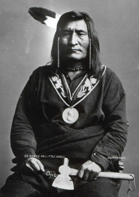
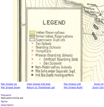
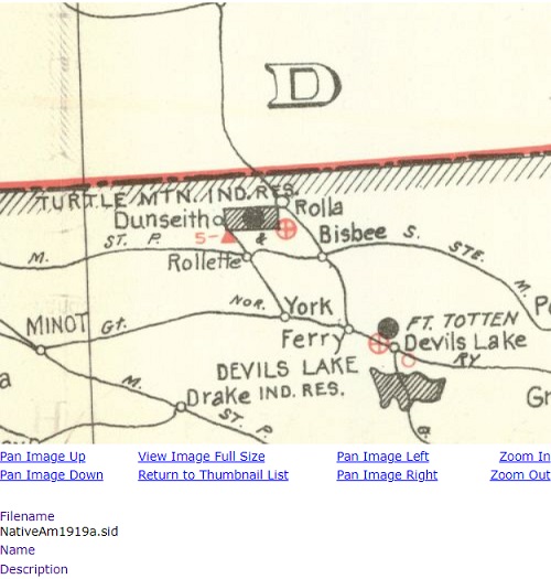
This Reservations history is extremely corrupt. Below are demographics and links to google maps photos of Belcourt, Green Acres and Dunseith Homesite. It is supposedly a former Ojibwa Reservation set aside on December 21, 1882. The map below is from 1919. Turtle Mountain Reservation and it's land allotments including Trenton Indian Service Area, belong to the Rocky Boy Tribe. Those land allotments covering 399,817.52 acres were distributed to chief Rocky Boys Montana Ojibwa Subjects. After Turtle Mountain Reservation was created in 1882, it's original land area was what is now Rollette County, North Dakota. It's land area was 937.0 sq. mi. or 2,430 sq. km. It didn't take long for this Ojibwa Reservation to bite the dust. Little Shell III was not an authentic Ojibwa leader. His grandfather was put in power by HBC (Hudson Bay Company) who established Ojibwa Family Inheritance leaders. His grandfather, who was an employee of HBC, was possibly lured to an HBC Trade Post at south Manitoba or northwest Ontario. After Ojibwa's lost 1774/1794's War they agreed to, by treaty agreements, allow England to establish HBC Trade Posts. NWC (North West Company) was established to challenge HBC. Little Shell III was easily persuaded to eradicate nearly all of Turtle Mountain Reservation. If the bribe money was substantial Little Shell III was most willing to illegally cede Reservation land. His family had been allies of whites since the 1790's. Below is a photo of Little Shell III. He was not an authentic Ojibwa leader. He was an "Employee" of Hudson Bay Company. You'll notice he's wearing a medallion he received from whites which signifies he sided with whites. Nearly everything written about Little Shell III are lies! The so called "10¢" an acre Treaty is bogus.
In 1884, Little Shell III ceded nearly all of Turtle Mountain Reservation in exchange for a substantial money payment. Later, 43,820 acres was allotted to 326 Ojibwa's. What was left was termed "Surplus Land" and ceded to the United States. It was reported in 1920, that the population of former Turtle Mountain Reservation was 3,423. Of that, 154 were full blood Ojibwa's and 3,269 were mixed. American leaders allowed many people that lived at Red River Colony, to settle at Turtle Mountain Reservation. Thus, many people living at former Turtle Mountain Reservation are predominantly white! What is now considered Turtle Mountain Reservation are land allotments belonging to the Rocky Boy Tribe of Ojibwa's. It's about the Great Falls, Montana region where the infamous Turtle Shaped Island is. Click Here to read Seven Fires Prophesy. Google maps photos of Belcourt do not include Little Shell III Road (Little Shell III was a traitor), Gabriel Dumont Drive, John Norquay Street, Cuthbert Grant Way and Christopher W. Davis Road. James Ibister Way, Sarah Riel Drive, Henry Budd Street, Francis Sinclair Street, Gilbert Gordon Street, William Hardesty Street and Louis Riel Drive also.
It's very obvious that Ojibwa's of Turtle Mountain Reservation can't determine anything at their own land. It's important that they change the names of those streets to Ojibwa names. The Metis are mixed whites or Celtic's, Dutch and Latin's. Ojibwa leaders did create an alliance with them during the 1770's and 1780's. American leaders refused to follow agreements they reached with Italian leaders of Quebec Colony around the early 1760's in which Quebec Colony became a protectorate of the United States. Benjamin Franklin created the government of the United States in 1754 using Articles of Confederation. American leaders eradicated the Dutch Colony and possible Celtic Colonies at Massachusetts. Though most stayed some fled to northwest Ontario and south Manitoba. They never became numerous. Perhaps 5,000 at the most at Saskatchewan. The Dutch were very defiant and most possibly left for South Africa and the Netherlands. Ojibwa leaders set aside a small Metis Colony at south Manitoba in the 1790's. However, England brought Red River Colony under their control shortly after the War of 1812. Metis leaders of Red River Colony then requested from Ojibwa leaders for another colony. Ojibwa leaders agreed and set aside a small Metis Colony along South Saskatchewan River. Louis Riel prevented a war at Red River Colony in 1869. He had no role in the 1885 Northwest Rebellion. He had already become a Canadian leader.
Belcourt Road View
Belcourt Road View
Belcourt Road View
Belcourt Road View
Belcourt Road View
Belcourt Road View
Belcourt Road View
Belcourt Road View
Belcourt Road View
Belcourt Road View
Belcourt Road View
Belcourt Road View
Belcourt Road View
Belcourt Road View
Belcourt Road View
Green Acres Road View
Green Acres Road View
Green Acres Road View
Green Acres Road View
Green Acres Road View
Green Acres Road View
Green Acres Road View
Green Acres Road View
Dunseith Homesite Road View
Dunseith Homesite Road View
Dunseith Homesite Road View
Dunseith Homesite Road View
Dunseith Homesite Road View
Dunseith Homesite Road View
Dunseith Homesite Road View
Dunseith Homesite Road View
Land Area: 693.5 sq. mi. or 1,796.1 sq. km.
Population: 7,747 (2020 census)
Ojibwa's: 92%
Whites: 4%
Mixe Bloods: 2% (it's much higher)
Mexicans: 1%
Asians: 1%
Language: Ojibwa
